Showing posts with label Atmospheric Remote Sensing. Show all posts

Tuesday, August 26, 2014

G band atmospheric radars: new frontiers in cloud physics

A. Battaglia1, C. D. Westbrook2, S. Kneifel3, P. Kollias3, N. Humpage1, U. Löhnert4, J. Tyynelä5, and G. W. Petty6

  • 1Department of Physics and Astronomy, University of Leicester, University Road, Leicester, UK
  • 2Department of Meteorology, University of Reading, Reading, UK
  • 3McGill University, Montreal, Canada
  • 4Institut für Geophysik und Meteorologie, University of Cologne, Cologne, Germany
  • 5Department of Physics, University of Helsinki, Helsinki, Finland
  • 6University of Wisconsin-Madison, Madison, Wisconsin, USA

Abstract. Clouds and associated precipitation are the largest source of uncertainty in current weather and future climate simulations. Observations of the microphysical, dynamical and radiative processes that act at cloud scales are needed to improve our understanding of clouds. The rapid expansion of ground-based super-sites and the availability of continuous profiling and scanning multi-frequency radar observations at 35 and 94 GHz have significantly improved our ability to probe the internal structure of clouds in high temporal-spatial resolution, and to retrieve quantitative cloud and precipitation properties. However, there are still gaps in our ability to probe clouds due to large uncertainties in the retrievals.

The present work discusses the potential of G band (frequency between 110 and 300 GHz) Doppler radars in combination with lower frequencies to further improve the retrievals of microphysical properties. Our results show that, thanks to a larger dynamic range in dual-wavelength reflectivity, dual-wavelength attenuation and dual-wavelength Doppler velocity (with respect to a Rayleigh reference), the inclusion of frequencies in the G band can significantly improve current profiling capabilities in three key areas: boundary layer clouds, cirrus and mid-level ice clouds, and precipitating snow.

Citation: Battaglia, A., Westbrook, C. D., Kneifel, S., Kollias, P., Humpage, N., Löhnert, U., Tyynelä, J., and Petty, G. W.: G band atmospheric radars: new frontiers in cloud physics, Atmos. Meas. Tech., 7, 1527-1546, doi:10.5194/amt-7-1527-2014, 2014.

Friday, April 25, 2014

The Python ART Radar Toolkit

The Python ARM Radar Toolkit, Py-ART, is a Python module containing a collection of weather radar algorithms and utilities. Py-ART is used by the Atmospheric Radiation Measurement (ARM) Climate Research Facility for working with data from a number of its precipitation and cloud radars, but has been designed so that it can be used by others in the radar and atmospheric communities to examine, processes, and analyze data from many types of weather radars.

What can Py-ART do?

Py-ART has the ability to ingest (read) from a number of common weather radar formats including Sigmet/IRIS, MDV, CF/Radial, UF, and NEXRAD Level II archive files. Radar data can be written to NetCDF files which conform to the CF/Radial convension.

Py-ART also contains routines which can produce common radar plots including PPIs and RHIs.

PPI Plot RHI Plot

Algorithms in the module are able to performs a number of corrections on the radar moment data in antenna coordinate including attenuation correction of the reflectivity, velocity dealiasing, and correction of the specific (Kdp) and differential (PhiDP) phases.

A sophisticated mapping routines is able to efficiently create uniform Cartesian grids of radar fields from one or more radars. Routines exist in Py-ART for plotting these grids as well as saving them to NetCDF files.

GitHub repository

Monday, March 10, 2014

WegenerNet: A Pioneering High-Resolution Network for Monitoring Weather and Climate

Gottfried Kirchengast, Thomas Kabas, Armin Leuprecht, Christoph Bichler, and Heimo Truhetz, 2014: WegenerNet: A Pioneering High-Resolution Network for Monitoring Weather and Climate. Bull. Amer. Meteor. Soc., 95, 227–242.
doi: http://dx.doi.org/10.1175/BAMS-D-11-00161.1

The Feldbach region in southeast Austria, characteristic for experiencing a rich variety of weather and climate patterns, has been selected as the focus area for a pioneering weather and climate observation network at very high resolution: The WegenerNet comprises 151 meteorological stations measuring temperature, precipitation, and other parameters, in a tightly spaced grid within an area of about 20 km × 15 km centered near the city of Feldbach (46.93°N, 15.90°E). With its stations about every 2 km2, each with 5-min time sampling, the network provides regular measurements since January 2007, after a pilot phase, until 2010, meanwhile in an operational manner. Quality-controlled station time series and gridded field data (spacing 200 m × 200 m) are available in near–real time (data latency less than 1–2 h) for visualization and download via a data portal (www.wegenernet.org; detailed information is available via www.wegcenter.at/wegenernet).

The WegenerNet region in southeast Austria

This paper introduces the WegenerNet from its design and setup via its processing system and data products to showing example results. The latter include extreme weather event examples, climate variability over the 5-yr period from 2007 to 2011, and an example of calibration support to coupled climate–hydrology modeling. The network is set to serve as a long-term monitoring and validation facility for weather and climate research and applications. Uses include validation of nonhydrostatic models operated at 1-km-scale resolution and of statistical downscaling techniques (in particular for precipitation), validation of weather radar and satellite data, study of orography–climate relationships, and many others.

Friday, February 28, 2014

Addison receives new weather radar technology

By ELIZABETH KNIGHTEN, Neighborsgo

Mark Acevedo, director of general services for the town of Addison, stands next to the town's recently installed Collaborative Adaptive Sensing of the Atmosphere radar unit.

ROSE BACA/neighborsgo staff photographer

Mark Acevedo, director of general services for the town of Addison, stands next to the town's recently installed Collaborative Adaptive Sensing of the Atmosphere radar unit. The unit scans the low levels of the atmosphere for severe weather, a view of developing storms that the long-range NEXRAD radar units can't provide.

Saturday, August 3, 2013

Radar-radiometer retrievals of cloud number concentration and dispersion parameter in nondrizzling marine stratocumulus


J. Rémillard1,*, P. Kollias1, and W. Szyrmer1

  • 1Department of Atmospheric and Oceanic Sciences, McGill University, Montreal, QC, Canada
  • *currently at: Department of Applied Physics and Applied Mathematics, Columbia University, New York, USA

Abstract. The retrieval of cloud microphysical properties from remote sensors is challenging. In the past, ground-based radar-radiometer measurements have been successfully used to retrieve the liquid water content profile in nondrizzling clouds but offer little constraint in retrieving other moments of the cloud particle size distribution (PSD). Here, a microphysical condensational model under steady-state supersaturation conditions is utilized to provide additional constraints to the well-established radar-radiometer retrieval techniques. The coupling of the model with the observations allows the retrieval of the three parameters of a lognormal PSD, with two of them being height dependent. Two periods of stratocumulus from the Azores are used to evaluate the novel technique. The results appear reasonable in two nondrizzling periods: continental-like number concentrations are retrieved, in agreement with the drizzle-free cloud conditions. The cloud optical depth derived from the retrieved distributions compares well in magnitude and variability with the one derived independently from a narrow field of view zenith radiometer. Uncertainties coming from the measurements are propagated to the retrieved quantities to estimate their errors. In general, errors smaller than 20% should be attainable for most parameters, demonstrating the added value of the new technique.

Citation: Rémillard, J., Kollias, P., and Szyrmer, W.: Radar-radiometer retrievals of cloud number concentration and dispersion parameter in nondrizzling marine stratocumulus, Atmos. Meas. Tech., 6, 1817-1828, doi:10.5194/amt-6-1817-2013, 2013.

Wednesday, June 27, 2012

Objective Optimization of Weather Radar Networks for Low-Level Coverage Using a Genetic Algorithm

James M. Kurdzo and Robert D. Palmer, 2012: Objective Optimization of Weather Radar Networks for Low-Level Coverage Using a Genetic Algorithm. J. Atmos. Oceanic Technol., 29, 807–821. doi: http://dx.doi.org/10.1175/JTECH-D-11-00076.1

The current Weather Surveillance Radar-1988 Doppler (WSR-88D) radar network is approaching 20 years of age, leading researchers to begin exploring new opportunities for a next-generation network in the United States. With a vast list of requirements for a new weather radar network, research has provided various approaches to the design and fabrication of such a network. Additionally, new weather radar networks in other countries, as well as networks on smaller scales, must balance a large number of variables in order to operate in the most effective way possible. To offer network designers an objective analysis tool for such decisions, a coverage optimization technique, utilizing a genetic algorithm with a focus on low-level coverage, is presented. Optimization is achieved using a variety of variables and methods, including the use of climatology, population density, and attenuation due to average precipitation conditions. A method to account for terrain blockage in mountainous regions is also presented. Various combinations of multifrequency radar networks are explored, and results are presented in the form of a coverage-based cost–benefit analysis, with considerations for total network

Thursday, June 7, 2012

An Extended Kalman Filter Framework for Polarimetric X-Band Weather Radar Data Processing

Marc Schneebeli and Alexis Berne, 2012: An Extended Kalman Filter Framework for Polarimetric X-Band Weather Radar Data Processing. J. Atmos. Oceanic Technol., 29, 711–730. doi: http://dx.doi.org/10.1175/JTECH-D-10-05053.1

Abstract The different quantities measured by dual-polarization radar systems are closely linked to each other. An extended Kalman filter framework is proposed in order to make use of constraints on individual radar observables that are induced by these relations. This new approach simultaneously estimates the specific differential phase on propagation Kdp, the attenuation-corrected reflectivity at horizontal polarization Zh, and the attenuation-corrected differential reflectivity Zdr, as well as the differential phase shift on backscatter δ. In a simulation experiment it is found that Kdp and δ can be retrieved with higher accuracy and spatial resolution than existing estimators that solely rely on a smoothed measurement of the differential phase shift Ψdp. Attenuation-corrected Zh was retrieved with an accuracy similar to standard algorithms, but improvements were found for attenuation-corrected Zdr. In addition, the algorithm can be used for radar calibration by comparing the directly retrieved differential phase shift on propagation Φdp with the accumulated Kdp estimates. The extended Kalman filter estimation scheme was applied to data collected with an X-band polarimetric radar in the Swiss Alps in 2010. Radome attenuation appears to be significant (up to 5 dB) in moderate to intense rain events and hence needs to be corrected in order to have reliable quantitative precipitation estimates. Measurements corrected for radome and propagation attenuation were converted into rain-rate R with a newly developed relation between R, Kdp, and Zdr. The good agreement between rain-rate values inferred from ground observations and from the radar measurements confirms the reliability of the proposed radar processing technique.

Tuesday, June 28, 2011

International X-Band Weather Radar Workshop, 14-16 November, 2011, Delft, Netherlands

The installation of compact X-band weather radars becomes increasingly popular as such radars deliver rainfall rate information in a very high spatial and temporal detail which are required for applications such as the monitoring of rainfall in urban areas or water catchment hydrology.

International X-Band Weather Radar Workshop, 14-16 November, 2011, Delft, Netherlands

However, X-band weather radar observations pose challenges e.g. in terms of the prevailing scattering mechanisms and the significant attenuation by rain which makes the seamless application of methods and algorithms developed for S- and C-band disputable.

The objective of this workshop is to serve as a platform for experts on X-band weather radar in order to discuss the latest developments in the field. A plenary discussion is scheduled to evaluate the state-of-the-art for rainfall measurements with X-band weather radar and to discuss the possibility of writing a reference book on this topic.

Prof. Dr. Clemens Simmer
Prof. Dr. Herman Russchenberg

Saturday, November 27, 2010

Multifunction Phased-Array Radar: Time Balance Scheduler for Adaptive Weather Sensing

Ricardo Reinoso-Rondinel, Tian-You Yu, and Sebastián Torres, 2010: Multifunction Phased-Array Radar: Time Balance Scheduler for Adaptive Weather Sensing. J. Atmos. Oceanic Technol., 27, 1854–1867. doi: http://dx.doi.org/10.1175/2010JTECHA1420.1

Abstract. Phased-array radars (PARs) have the capability of instantaneously and dynamically controlling beam position on a pulse-by-pulse basis, which allows a single radar to perform multiple functions, such as tracking multiple storms or weather and aviation surveillance. Moreover, these tasks can be carried out with different update times to achieve the goal of better characterizing and forecasting the storms of interest. However, these tasks usually compete for finite radar resources, and scheduling algorithms are often needed to address resource contention. To capitalize on the PAR capabilities, an algorithm based on the concept of time balance (TB) is developed for adaptive weather sensing. Two quality measures are introduced to quantify the gain of adaptive sensing relative to standard scanning patterns used by the Weather Surveillance Radar-1988 Doppler (WSR-88D). A simulation experiment is performed to demonstrate the advantages of adaptive sensing and to test and verify the performance of the TB scheduling algorithm. It is shown that the gain of adaptive sensing can be realized by the TB scheduler; that is, storms of interest can be revisited more frequently within a relatively short period time compared to conventional scanning.

Sunday, December 27, 2009

Short-Wavelength Technology and the Potential For Distributed Networks of Small Radar Systems

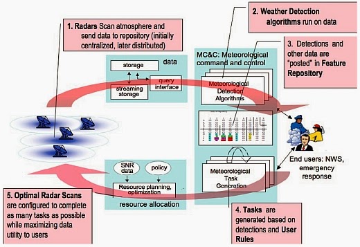
David McLaughlin, David Pepyne, Brenda Philips, James Kurose, Michael Zink, David Westbrook, Eric Lyons, Eric Knapp, Anthony Hopf, Alfred Defonzo, Robert Contreras, Theodore Djaferis, Edin Insanic, Stephen Frasier, V. Chandrasekar, Francesc Junyent, Nitin Bharadwaj, Yanting Wang, Yuxiang Liu, Brenda Dolan, Kelvin Droegemeier, Jerald Brotzge, Ming Xue, Kevin Kloesel, Keith Brewster, Frederick Carr, Sandra Cruz-Pol, Kurt Hondl, and Pavlos Kollias, 2009: Short-Wavelength Technology and the Potential For Distributed Networks of Small Radar Systems. Bull. Amer. Meteor. Soc., 90, 1797–1817. doi: http://dx.doi.org/10.1175/2009BAMS2507.1 -
http://journals.ametsoc.org/doi/abs/10.1175/2009BAMS2507.1

CASA project: Flow diagram depicting the major processing steps of the closed-loop software architectureFlow diagram depicting the major processing steps of the closed-loop software architecture

Abstract. Dense networks of short-range radars capable of mapping storms and detecting atmospheric hazards are described. Composed of small X-band (9.4 GHz) radars spaced tens of kilometers apart, these networks defeat the Earth curvature blockage that limits today's long-range weather radars and enables observing capabilities fundamentally beyond the operational state-of-the-art radars. These capabilities include multiple Doppler observations for mapping horizontal wind vectors, subkilometer spatial resolution, and rapid-update (tens of seconds) observations extending from the boundary layer up to the tops of storms. The small physical size and low-power design of these radars permits the consideration of commercial electronic manufacturing approaches and radar installation on rooftops, communications towers, and other infrastructure elements, leading to cost-effective network deployments. The networks can be architected in such a way that the sampling strategy dynamically responds to changing weather to simultaneously accommodate the data needs of multiple types of end users. Such networks have the potential to supplement, or replace, the physically large long-range civil infrastructure radars in use today.

Friday, February 20, 2009

RONSARD Radar: Implementation of Dual Polarization on a C-Band Doppler Weather Radar

The French C-band meteorological Doppler radar Recherche sur les Orages et Nuages par un Systeme Associe de Radars Doppler (RONSARD) was recently equipped with dual polarization. This modification required, on the one hand, an additional receiver and, on the other hand, a new design for the antenna geometry in order to decrease strongly the sidelobe level. This new radar configuration allows us to choose between two complementary modes: (1) the previous single-polarization mode, still preserved with fast Fourier transform calculations of the first three momentums of the Doppler spectrum, i.e., horizontal (H) reflectivity, radial wind velocity, and wind velocity variance calculated both in precipitation areas and clear air areas (depending on the gate), and (2) the dual-polarization mode with pulse pair processing of H and vertical reflectivities and velocities, differential phase shift, and coherence coefficient. Moreover, both modes work over contiguous gates along each direction, allowing fine radial range resolution. Thanks to the flexibility between these two modes, the RONSARD radar becomes a new major facility aimed at studying the dynamics-microphysics interactions within precipitation and their environment. - Reference

Tuesday, February 17, 2009

A Polarimetric Radar Forward Operator for Model Evaluation

A polarimetric radar forward operator has been developed as a tool for the systematic evaluation of microphysical parameterization schemes in high-resolution numerical weather prediction (NWP) models. The application of such a forward operator allows a direct comparison of the model simulations to polarimetric radar observations. While the comparison of observed and synthetic reflectivity gives information on the quality of quantitative precipitation forecasts, the information from the polarimetric quantities allows for a direct evaluation of the capacity of the NWP model to realistically describe the processes involved in the formation and interactions of the hydrometeors and, hence, the performance of the microphysical parameterization scheme. This information is expected to be valuable for detecting systematic model errors and hence improve model physics. This paper summarizes the technical characteristics of the synthetic polarimetric radar (SynPolRad). Different polarimetric radar quantities are computed from model forecasts using a T-matrix scattering code and ice phase hydrometeors are explicitly considered. To do so, the sensitivities of the scattering processes to the microphysical characteristics of different ice hydrometeors are investigated using sensitivity studies. Furthermore, beam propagation effects are considered, including attenuation and beam bending. The performance of SynPolRad and the consistence of the assumptions made in the derivation of the input parameters are illustrated in a case study. The resulting synthetic quantities as well as hydrometeor classification are compared with observations and are shown to be consistent with the model assumptions.- Reference

An Analysis of Errors in Drop Size Distribution Retrievals and Rain Bulk Parameters with a UHF Wind Profiling Radar and a Two-Dimensional Video Disdrometer

Vertically pointed wind profiling radars can be used to obtain measurements of the underlying drop size distribution (DSD) for a rain event by means of the Doppler velocity spectrum. Precipitation parameters such as rainfall rate, radar reflectivity factor, liquid water content, mass-weighted mean drop diameter, and median volume drop diameter can then be calculated from the retrieved DSD. The DSD retrieval process is complicated by the presence of atmospheric turbulence, vertical ambient air motion, selection of fall speed relationships, and velocity thresholding. In this note, error analysis is presented to quantify the effect of each of those factors on rainfall rate. The error analysis results are then applied to two precipitation events to better interpret the rainfall-rate retrievals.

It was found that a large source of error in rain rate is due to unaccounted-for vertical air motion. For example, in stratiform rain with a rainfall rate of R = 10 mm h−1, a mesoscale downdraft of 0.6 m s−1 can result in a 34% underestimation of the estimated value of R. The fall speed relationship selection and source of air density information both caused negligible errors. Errors due to velocity thresholding become more important in the presence of significant contamination near 0 m s−1, such as ground clutter. If particles having an equivalent volume diameter of 0.8 mm and smaller are rejected, rainfall rate errors from −4% to −10% are possible, although these estimates depend on DSD and rainfall rate.- Reference

Coupled Contributions in the Doppler Radar Spectrum Width Equation

Contrary to accepted usage, the second central moment of the Doppler spectrum is not the sum of the second central moments of individual spectral broadening mechanisms. A rigorous theoretical derivation of the spectrum width observed with short dwell times reveals that the sum cannot strictly be taken for the variances associated with various spectral broadening mechanisms and that an added-term coupling shear with turbulence is needed. Furthermore, shear and antenna rotation are coupled. The theoretical expressions derived herein apply to radars with fixed or scanning beams.- Reference

Clutter Suppression for Staggered PRT Waveforms

This paper presents a clutter suppression methodology for staggered pulse repetition time (PRT) observations. It is shown that spectral moments of precipitation echoes can be accurately estimated even in cases where clutter-to-signal ratios are high by using a parametric time domain method (PTDM).

Based on radar signal simulations, the accuracy of the proposed method is evaluated for various observation conditions. The performance of PTDM is demonstrated by the implementation of the staggered PRT at the Colorado State University–University of Chicago–Illinois State Water Survey (CSU–CHILL). Based on this study, it is found that the accuracy of the retrieval is comparable to the current state of the art methods applied to the uniformly sampled observations and that the estimated velocity is unbiased for the complete Nyquist range.- Reference

Effects of Multiple Scattering on Attenuation-Based Retrievals of Stratiform Rainfall from CloudSat

An attenuation-based method to retrieve vertical profiles of rainfall rates from height derivatives/gradients of CloudSat nadir-pointing W-band reflectivity measurements is discussed. This method takes advantage of the high attenuation of W-band frequency signals in rain and the low variability of nonattenuated reflectivity due to strong non-Rayleigh scattering from rain drops. The retrieval uncertainties could reach 40%–50%. The suggested method is generally applicable to rainfall rates (R) in an approximate range from about 2–3 to about 20–25 mm h−1. Multiple scattering noticeably affects the gradients of CloudSat measurements for R values greater than about 5 mm h−1. To avoid a retrieval bias caused by multiple-scattering effects, a special correction for retrievals is introduced. For rainfall rates greater than about 25 mm h−1, the influence of multiple scattering gets overwhelming, and the retrievals become problematic, especially for rainfalls with higher freezing-level altitudes. The attenuation-based retrieval method was applied to experimental data from CloudSat covering the range of rainfall rates. CloudSat retrievals were compared to the rainfall estimates available from a National Weather Service ground-based scanning precipitation radar operating at S band. Comparisons between spaceborne and conventional radar rainfall retrievals were generally in good agreement and indicated the mutual consistency of both quantitative precipitation estimate types. The suggested CloudSat rainfall retrieval method is immune to the absolute calibration of the radar and to attenuation caused by the melting layer and snow regions. Since it does not require surface returns, it is applicable to measurements above both land and water surfaces.- Reference