Showing posts with label SAR. Show all posts

Friday, April 4, 2014

Get ready for software-defined RADAR

With a big RF transmitter and enough fast computing power, you have the ability to do a lot of different things, as evidenced by a General Electric presentation on "software-defined radar" at the GPU conference this year.

At GTC 13 last year, GE gave a standing-room-only presentation about how it's using RDMA (Remote Direct Memory Access) to drive multi-GPU process performance to new heights. The firm was back this year to talk about new and innovative applications of GPU tech it has cooked up over the past year.

How it works: Simultaneous transmit/receive for a whole load of functions

How it works: Simultaneous transmit/receive for a whole load of functions

In its session, Dustin Franklin, GE GPU Applications Engineer guru, gives us an update on how it has been proceeding with RDMA and how it allows the electric company to build large scale, multi-node, products.
Sunday, March 9, 2014

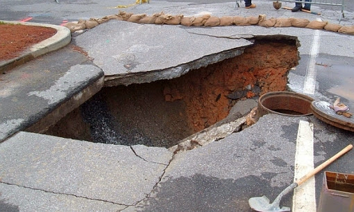
NASA could predict sinkholes with space radar

NASA announced Friday that it may have found a way to predict sinkholes up to a month before they occur. The warning would be provided by interferometric synthetic aperture radar (iSAR), which could be placed on satellites or planes to scan areas prone to sinkholes.

NASA may be able to use interferometric synthetic aperture radar (iSAR) to predict sinkholes up to a month before they occur. Sinkholes are depressions in the ground formed when layers of the earth's surface fall into underground caverns. Usually they form without warning. (Photo : Scott Ehardt | Wikimedia Commons)

iSAR scans the ground several times in several different wavelengths to put together interferograms, which can show small movements of the Earth such as the effect of flooding on riverbanks, the ripples of earthquakes and where the ground is sinking.

Sinkholes are depressions in the ground formed when layers of the earth's surface fall into underground caverns. Usually they form without warning.

Saturday, March 26, 2011

A signal processing view of strip-mapping synthetic aperture radar

Munson, D.C., Jr.; Visentin, R.L., "A signal processing view of strip-mapping synthetic aperture radar," Acoustics, Speech and Signal Processing, IEEE Transactions on , vol.37, no.12, pp.2131,2147, Dec 1989. doi: 10.1109/29.45556

Abstract: The authors derive the fundamental strip-mapping SAR (synthetic aperture radar) imaging equations from first principles. They show that the resolution mechanism relies on the geometry of the imaging situation rather than on the Doppler effect. Both the airborne and spaceborne cases are considered. Range processing is discussed by presenting an analysis of pulse compression and formulating a mathematical model of he radar return signal. This formulation is used to obtain the airborne SAR model. The authors study the resolution mechanism and derive the signal processing relations needed to produce a high-resolution image. They introduce spotlight-mode SAR and briefly indicate how polar-format spotlight processing can be used in strip-mapping SAR. They discuss a number of current and future research directions in SAR imaging

Reference

Wide-angle radar imaging using time-frequency distributions

Lanterman, A.D.; Munson, D.C., Jr.; Wu, Y., "Wide-angle radar imaging using time-frequency distributions," Radar, Sonar and Navigation, IEE Proceedings - , vol.150, no.4, pp.203-11,, 1 Aug. 2003. doi: 10.1049/ip-rsn:20030712

Abstract: Low-frequency radar systems provide some attractive advantages in a few niche applications, such as foliage penetration and covert operation. In low-frequency imaging systems, data must be collected over a wide range of angles to obtain cross-range resolution comparable to that obtainable from a competing small-angle high-frequency system. The reflectivity of a target varies with aspect angle; although this variation is usually ignored by traditional radar imaging algorithms, it sometimes cannot be neglected in wide-angle scenarios. To account for aspect dependence of reflectivity, time-frequency transforms have been invoked to generate a series of images corresponding to different look angles; these images may be considered individually or synthesised into a single image. A simple theoretical analysis with a point scatterer illustrates why the angular dependence needs explicit consideration. The potential of time-frequency methods is illustrated via simulations

Reference

Monday, September 29, 2008

A Two-Dimensional Spectrum Model for General Bistatic SAR

This paper derives a 2-D spectrum model for general bistatic synthetic aperture radar (SAR). By introducing some new parameters such as equivalent monostatic parameters, bistatic factor, and weighted-equivalent range, the 2-D spectrum of general bistatic SAR can be expressed in the form of monostatic SAR even when the transmitter and receiver move along unparallel trajectories with different velocities. The result formulates bistatic SAR into an equivalent monostatic SAR model and would be useful for developing efficient bistatic SAR algorithms in frequency-domain or hybrid-domain processing. Simulation results are given to validate the performance of the model. For special bistatic SAR configurations, the model can be simplified. Compared to other similar models, the proposed model is clearer and much more concise. - Reference

Information Theory-Based Approach for Contrast Analysis in Polarimetric and/or Interferometric SAR Images

We propose a new approach for evaluating the contribution of the different channels of polarimetric and interferometric synthetic aperture radar (PolInSAR) images. For that purpose, we demonstrate that the Bhattacharyya distance between the probability density functions of neighboring regions in the image provides an efficient scalar contrast measure. We show that the analysis of this contrast measure allows one to precisely characterize the contribution of each channel for different system configurations, including intensity, polarimetric, and interferometric images. We illustrate this approach using a real synthetic aperture radar image to compare several polarimetric system architectures. Since PolInSAR imaging configurations can correspond to complex and expensive systems, the proposed method can be helpful in system imaging optimization. - Reference

Imaging Simulation of Bistatic Synthetic Aperture Radar and Its Polarimetric Analysis

Employing the 3-D mapping and projection algorithm (MPA), an imaging simulation of bistatic synthetic aperture radar (BISAR) observation over a complex scenario is developed. Based on the explicit expression of the point target response of stripmap BISAR imaging, raw data are efficiently generated from the scattering map precalculated by MPA. Some examples of BISAR image simulation are studied. The polarimetric characteristics of a BISAR image are then discussed. It is found that some typical polarimetric parameters such as Cloude's $alpha$, $beta$, and $gamma$ might become unable to describe the scattering mechanism under bistatic observation. A transform of unified bistatic polar bases for a BISAR image is proposed. The parameters $\alpha$, $\beta$ , and $\gamma$ are modified to retain the property of orientation independence in the bistatic circumstance. Analysis of simulated images shows that the redefined $\alpha$, $\beta$ , and $\gamma$ after the unified bistatic polar bases transform well describe different scattering mechanisms in BISAR imaging. It provides a primary tool for BISAR image interpretation and terrain classification. Reference

Friday, January 11, 2008

PAMIR (Phased Array Multifunctional Imaging Radar)

PAMIR is an airborne SAR/MTI (Synthetic Aperture Radar/Moving Target Indication) experimental instrument of FGAN/FHR. The multifunctional PAMIR instrument is of AER (Airborne Experimental Radar) and AER-II heritage, both of FGAN/FHR. more...

Friday, October 5, 2007

Cassini RADAR view of Titan's north pole

Cassini RADAR mosaic view of Titan's north pole

This mosaic is composed of all synthetic-aperture-radar maps of Titan's polar regions acquired by Cassini to date. It has been cropped and reduced in size by 50% from an even larger mosaic available on NASA's Planetary Photojournal. Approximately 60 percent of Titan's northern polar region (poleward of 60 degrees north latitude) has been mapped as of October 2007, and of this area, about 14% appears to be covered with hydrocarbon lakes. The radar images are grayscale; they have been colored here with a color map that applies blue colors to the materials that are darkest to the RADAR instrument, and yellow colors to the materials that are brightest. This color scheme highlights the apparent lakes, but also shows that many lake-like features are not as dark as other lakes, and that darker channels appear to run down the interiors of less dark lakes.

The image is a polar projection, with zero longitude (the sub-Saturnian hemisphere) toward the bottom. The leading hemisphere (centered at 90 degrees W) is to the left, and the trailing hemisphere (centered at 270 degrees W) is to the right. The largest lakes are clustered in an area on Titan's trailing hemisphere.

NASA / JPL-Caltech