Showing posts with label Radar networks. Show all posts

Monday, March 10, 2014

WegenerNet: A Pioneering High-Resolution Network for Monitoring Weather and Climate

Gottfried Kirchengast, Thomas Kabas, Armin Leuprecht, Christoph Bichler, and Heimo Truhetz, 2014: WegenerNet: A Pioneering High-Resolution Network for Monitoring Weather and Climate. Bull. Amer. Meteor. Soc., 95, 227–242.
doi: http://dx.doi.org/10.1175/BAMS-D-11-00161.1

The Feldbach region in southeast Austria, characteristic for experiencing a rich variety of weather and climate patterns, has been selected as the focus area for a pioneering weather and climate observation network at very high resolution: The WegenerNet comprises 151 meteorological stations measuring temperature, precipitation, and other parameters, in a tightly spaced grid within an area of about 20 km × 15 km centered near the city of Feldbach (46.93°N, 15.90°E). With its stations about every 2 km2, each with 5-min time sampling, the network provides regular measurements since January 2007, after a pilot phase, until 2010, meanwhile in an operational manner. Quality-controlled station time series and gridded field data (spacing 200 m × 200 m) are available in near–real time (data latency less than 1–2 h) for visualization and download via a data portal (www.wegenernet.org; detailed information is available via www.wegcenter.at/wegenernet).

The WegenerNet region in southeast Austria

This paper introduces the WegenerNet from its design and setup via its processing system and data products to showing example results. The latter include extreme weather event examples, climate variability over the 5-yr period from 2007 to 2011, and an example of calibration support to coupled climate–hydrology modeling. The network is set to serve as a long-term monitoring and validation facility for weather and climate research and applications. Uses include validation of nonhydrostatic models operated at 1-km-scale resolution and of statistical downscaling techniques (in particular for precipitation), validation of weather radar and satellite data, study of orography–climate relationships, and many others.
Monday, April 15, 2013

Cognitive Radar Network: Cooperative Adaptive Beamsteering for Integrated Search-and-Track Application

Romero, R.A.; Goodman, N.A., "Cognitive Radar Network: Cooperative Adaptive Beamsteering for Integrated Search-and-Track Application," Aerospace and Electronic Systems, IEEE Transactions on , vol.49, no.2, pp.915,931, APRIL 2013
doi: 10.1109/TAES.2013.6494389

Abstract: Cognitive radar (CR) is a paradigm shift from a traditional radar system in that previous knowledge and current measurements obtained from the radar channel are used to form a probabilistic understanding of its environment. Moreover, CR incorporates this probabilistic knowledge into its task priorities to form illumination and probing strategies, thereby rendering it a closed-loop system. Depending on the hardware's capabilities and limitations, there are various degrees of freedom that a CR may utilize. Here we concentrate on spatial illumination as a resource, where adaptive beamsteering is used for search-and-track functions. We propose a multiplatform cognitive radar network (CRN) for integrated search-and-track application. Specifically, two radars cooperate in forming a dynamic spatial illumination strategy, where beamsteering is matched to the channel uncertainty to perform the search function. Once a target is detected and a track is initiated, track information is integrated into the beamsteering strategy as part of CR's task prioritization.

Source

Wednesday, June 27, 2012

Objective Optimization of Weather Radar Networks for Low-Level Coverage Using a Genetic Algorithm

James M. Kurdzo and Robert D. Palmer, 2012: Objective Optimization of Weather Radar Networks for Low-Level Coverage Using a Genetic Algorithm. J. Atmos. Oceanic Technol., 29, 807–821. doi: http://dx.doi.org/10.1175/JTECH-D-11-00076.1

The current Weather Surveillance Radar-1988 Doppler (WSR-88D) radar network is approaching 20 years of age, leading researchers to begin exploring new opportunities for a next-generation network in the United States. With a vast list of requirements for a new weather radar network, research has provided various approaches to the design and fabrication of such a network. Additionally, new weather radar networks in other countries, as well as networks on smaller scales, must balance a large number of variables in order to operate in the most effective way possible. To offer network designers an objective analysis tool for such decisions, a coverage optimization technique, utilizing a genetic algorithm with a focus on low-level coverage, is presented. Optimization is achieved using a variety of variables and methods, including the use of climatology, population density, and attenuation due to average precipitation conditions. A method to account for terrain blockage in mountainous regions is also presented. Various combinations of multifrequency radar networks are explored, and results are presented in the form of a coverage-based cost–benefit analysis, with considerations for total network

Sunday, December 27, 2009

Short-Wavelength Technology and the Potential For Distributed Networks of Small Radar Systems

David McLaughlin, David Pepyne, Brenda Philips, James Kurose, Michael Zink, David Westbrook, Eric Lyons, Eric Knapp, Anthony Hopf, Alfred Defonzo, Robert Contreras, Theodore Djaferis, Edin Insanic, Stephen Frasier, V. Chandrasekar, Francesc Junyent, Nitin Bharadwaj, Yanting Wang, Yuxiang Liu, Brenda Dolan, Kelvin Droegemeier, Jerald Brotzge, Ming Xue, Kevin Kloesel, Keith Brewster, Frederick Carr, Sandra Cruz-Pol, Kurt Hondl, and Pavlos Kollias, 2009: Short-Wavelength Technology and the Potential For Distributed Networks of Small Radar Systems. Bull. Amer. Meteor. Soc., 90, 1797–1817. doi: http://dx.doi.org/10.1175/2009BAMS2507.1 -
http://journals.ametsoc.org/doi/abs/10.1175/2009BAMS2507.1

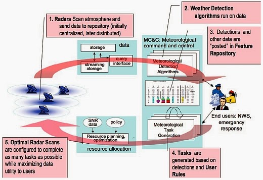
CASA project: Flow diagram depicting the major processing steps of the closed-loop software architectureFlow diagram depicting the major processing steps of the closed-loop software architecture

Abstract. Dense networks of short-range radars capable of mapping storms and detecting atmospheric hazards are described. Composed of small X-band (9.4 GHz) radars spaced tens of kilometers apart, these networks defeat the Earth curvature blockage that limits today's long-range weather radars and enables observing capabilities fundamentally beyond the operational state-of-the-art radars. These capabilities include multiple Doppler observations for mapping horizontal wind vectors, subkilometer spatial resolution, and rapid-update (tens of seconds) observations extending from the boundary layer up to the tops of storms. The small physical size and low-power design of these radars permits the consideration of commercial electronic manufacturing approaches and radar installation on rooftops, communications towers, and other infrastructure elements, leading to cost-effective network deployments. The networks can be architected in such a way that the sampling strategy dynamically responds to changing weather to simultaneously accommodate the data needs of multiple types of end users. Such networks have the potential to supplement, or replace, the physically large long-range civil infrastructure radars in use today.