This document discusses the principles and signal processing techniques of Frequency-Modulated Continuous-Wave (FMCW) radars, focusing on linear FMCW radar for precipitation measurements. It explains the modulation process that enables ranging capabilities, Doppler frequency shifts related to moving targets, and provides an overview of the IDRA drizzle radar system developed at the Delft University of Technology. The document includes specific technical specifications and a block diagram of the radar system, emphasizing its applications in atmospheric remote sensing.
Showing posts with label Weather radars. Show all posts
Showing posts with label Weather radars. Show all posts
Wednesday, January 13, 2016
Tuesday, August 19, 2014
National Weather Service in Raleigh debuts faster Doppler radar
Meteorologists at the National Weather Service in Raleigh recently got an upgrade to their Doppler radar, giving them more data and quicker updates when the weather turns severe.
The upgrade, called SAILS, or Supplemental Adaptive Intra-Volume Low-Level Scan, allows the meteorologists to get radar images from the lowest part of the storm every 2 minutes instead of every 4.
“More frequent updates of what's going on near the ground gives us a better idea of what's about to hit the ground or impact the ground,” said NWS meteorologist Jonathan Blaes.
Blaes says the radar does more than just show where it’s raining. “It scans at multiple slices to get a 3D view of precipitation, thunderstorms and other phenomena,” he said.
Seeing what's happening inside a storm gives forecasters an idea of how dangerous it is and can tell them if a tornado is forming.
“The more observations you can get the closer to where people live, that's always helpful,” WRAL Chief Meteorologist Greg Fishel said.
WRAL’s DUALDoppler5000 radar scans the lowest layer of the atmosphere once every minute. That radar, along with the Weather Service's newly upgraded Doppler radar, gives forecasters a better chance of spotting dangerous storms. That helps them issue better warnings and save more lives.
“More data is always better, and that's what we're excited about,” Fishel said.
The National Weather Service radar upgrade is in place now, ready for the next severe weather season, which typically happens in the fall. Another upgrade is planned within the next year to allow even more frequent updates.
The National Weather Service is working on a new kind of radar system, already used in the military, called Phased Array Radar. It will scan in less than one minute and cost less to operate. It likely will be a decade before those radars are installed, Blaes said.
Friday, August 15, 2014
Radar software may fix weather forecast issues caused by wind farms

The movement of wind turbine propellers can mimic weather when viewed by the Doppler radar used by Environment Canada to predict storms. (Robert F. Bukaty/Associated Press)
Environment Canada is preparing to roll out new radar technology in order to combat wind farm clutter, which clouds weather forecasts, misleads meteorologists and can even block radar signals.
Jim Young, who works at the agency's national radar program, said new software will be incorporated into Canada's radar system this fall in an effort to address the "contamination" caused by wind turbines.
Tuesday, August 12, 2014
Environment Canada testing radar software to combat wind farm clutter

Wind turbines are shown in this file photo. (The Canadian Press/Dave Chidley)
Clare Clancy, The Canadian Press Published Sunday, August 10, 2014 9:20AM EDT
TORONTO -- Environment Canada is preparing to roll out new radar technology in order to combat wind farm clutter, which clouds weather forecasts, misleads meteorologists and can even block radar signals.
Jim Young, who works at the agency's national radar program, said new software will be incorporated into Canada's radar system this fall in an effort to address the "contamination" caused by wind turbines.
"I certainly have very high hopes," he said, adding that Environment Canada has been concerned about wind farm clutter for years.
The agency uses Doppler radar to predict storms, but the movement of wind turbine propellers can mimic weather.
Tuesday, July 8, 2014
Change in NWS Doppler Radar Scanning Strategy Will Provide Much Needed Data and Should Lead to Improved Warnings
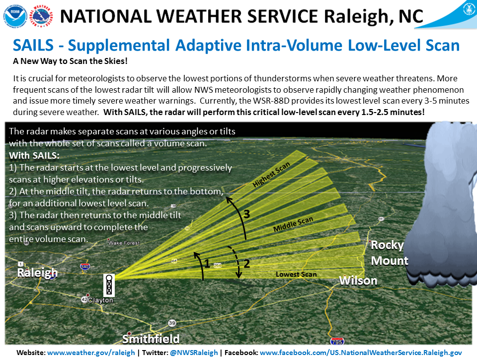
A new software upgrade installed at the National Weather Service (NWS) Raleigh Doppler radar (KRAX) today, July 8th, is expected to have a significant impact in severe weather operations. Around two-thirds of all NWS Doppler radars have been upgraded as of today, with the rest likely occurring during the next few months. You can view the current build of each NWS radar here (radar’s with the upgrade have the RPG build listed as “14.1”). The software change will allow the WSR-88D radar to obtain the lowest level radar scan more frequently during severe weather events.
With this upgrade, a new feature called SAILS (Supplemental Adaptive Intra-Volume Low-Level Scan) will enable the radar to insert an additional 0.5 degree scan in the middle of a volume scan (see the illustration below for more details). Currently, the WSR-88D radar completes its lowest scan in 3 to 4.3 minutes (during severe weather), depending on the range of the storms from the radar. With SAILS, the radar can now perform this low-level scan every 1.9 to 2.5 minutes, obtaining a 0.5 degree scan almost twice as frequently as before and providing NWS meteorologists with the ability to observe rapidly changing weather phenomenon more frequently and issue more timely severe weather warnings.
A training presentation was provided to NWS Raleigh partners detailing some of the changes with the build, it can be accessed here. The Warning Decision Training Branch (WDTB) has other training resources that are available online as well – RDA/RPG Build 14.0/RPG Build 14.1 training.
Friday, April 25, 2014
The Python ART Radar Toolkit
The Python ARM Radar Toolkit, Py-ART, is a Python module containing a collection of weather radar algorithms and utilities. Py-ART is used by the Atmospheric Radiation Measurement (ARM) Climate Research Facility for working with data from a number of its precipitation and cloud radars, but has been designed so that it can be used by others in the radar and atmospheric communities to examine, processes, and analyze data from many types of weather radars.
What can Py-ART do?
Py-ART has the ability to ingest (read) from a number of common weather radar formats including Sigmet/IRIS, MDV, CF/Radial, UF, and NEXRAD Level II archive files. Radar data can be written to NetCDF files which conform to the CF/Radial convension.
Py-ART also contains routines which can produce common radar plots including PPIs and RHIs.


Algorithms in the module are able to performs a number of corrections on the radar moment data in antenna coordinate including attenuation correction of the reflectivity, velocity dealiasing, and correction of the specific (Kdp) and differential (PhiDP) phases.
A sophisticated mapping routines is able to efficiently create uniform Cartesian grids of radar fields from one or more radars. Routines exist in Py-ART for plotting these grids as well as saving them to NetCDF files.
Monday, March 10, 2014
WegenerNet: A Pioneering High-Resolution Network for Monitoring Weather and Climate
Gottfried Kirchengast, Thomas Kabas, Armin Leuprecht, Christoph Bichler, and Heimo Truhetz, 2014: WegenerNet: A Pioneering High-Resolution Network for Monitoring Weather and Climate. Bull. Amer. Meteor. Soc., 95, 227–242.
doi: http://dx.doi.org/10.1175/BAMS-D-11-00161.1
The Feldbach region in southeast Austria, characteristic for experiencing a rich variety of weather and climate patterns, has been selected as the focus area for a pioneering weather and climate observation network at very high resolution: The WegenerNet comprises 151 meteorological stations measuring temperature, precipitation, and other parameters, in a tightly spaced grid within an area of about 20 km × 15 km centered near the city of Feldbach (46.93°N, 15.90°E). With its stations about every 2 km2, each with 5-min time sampling, the network provides regular measurements since January 2007, after a pilot phase, until 2010, meanwhile in an operational manner. Quality-controlled station time series and gridded field data (spacing 200 m × 200 m) are available in near–real time (data latency less than 1–2 h) for visualization and download via a data portal (www.wegenernet.org; detailed information is available via www.wegcenter.at/wegenernet).

This paper introduces the WegenerNet from its design and setup via its processing system and data products to showing example results. The latter include extreme weather event examples, climate variability over the 5-yr period from 2007 to 2011, and an example of calibration support to coupled climate–hydrology modeling. The network is set to serve as a long-term monitoring and validation facility for weather and climate research and applications. Uses include validation of nonhydrostatic models operated at 1-km-scale resolution and of statistical downscaling techniques (in particular for precipitation), validation of weather radar and satellite data, study of orography–climate relationships, and many others.
Friday, February 28, 2014
Addison receives new weather radar technology
By ELIZABETH KNIGHTEN, Neighborsgo

ROSE BACA/neighborsgo staff photographer
Mark Acevedo, director of general services for the town of Addison, stands next to the town's recently installed Collaborative Adaptive Sensing of the Atmosphere radar unit. The unit scans the low levels of the atmosphere for severe weather, a view of developing storms that the long-range NEXRAD radar units can't provide.
Tuesday, February 4, 2014
Rockwell Collins unveils new MultiScan ThreatTrack™ weather radar
-
Uses Predictive Overflight™ to identify significant turbulence threats above rapidly growing thunderstorms
-
First radar in industry to feature two levels of turbulence detection
-
American Airlines to take first delivery on new Next-Generation Boeing 737
CEDAR RAPIDS, Iowa (Feb. 4. 2014) – Rockwell Collins today unveiled its new MultiScan ThreatTrack™ weather radar, which provides unprecedented atmospheric threat assessment capabilities for air transport aircraft. The company will be showcasing the new system at next week’s Singapore Airshow.
MultiScan ThreatTrack builds upon Rockwell Collins’ market-leading MultiScan weather radar to deliver additional features and to further increase safety and efficiency. For example, the system’s advanced capabilities go beyond hail and lightning prediction within a thunderstorm cell and alerts pilots to these significant threats adjacent to the cell. If these thunderstorms are growing ahead and below the aircraft, ThreatTrack’s Predictive Overflight™ protection warns the flight crew if the cells will be in the aircraft’s flight path.
In addition, MultiScan ThreatTrack is the first in the industry to feature two levels of turbulence detection — severe and ride-quality—which more accurately informs flight crews of the type of turbulence in their path.
American Airlines is debuting the new radar, which was developed with extensive meteorological research and rigorous flight testing around the world, on its new Next-Generation Boeing 737 fleet.
“Working with American and Boeing, we certified a more comprehensive radar system that improves flight operations efficiency by helping pilots better navigate disruptive weather threats,” said Steve Timm, vice president and general manager, Air Transport Systems for Rockwell Collins. “With MultiScan ThreatTrack, passenger satisfaction will increase with smoother flights and more on-time arrivals.”
“American Airlines is pleased to collaborate with Rockwell Collins on the successful certification and entry into service of MultiScan ThreatTrack,” said Capt. Brian Will, director of Airspace Modernization and Advanced Technologies at American Airlines. “The system’s capabilities, including its advanced environmental threat detection logic, will help American continue to provide the safest and most efficient operation possible.”
In a research project sponsored by the NASA Weather Accident Prevention Project, data examined over the past two decades indicates that turbulence resulting in minor or major injury has cost airlines anywhere from $28,000 to $167,000 per incident. With an average of 750 turbulence encounters per year, the resulting cost to the industry can be $30 to $60 million per year. Lightning and hail damage to aircraft can increase the related costs exponentially.
MultiScan ThreatTrack weather radar is the first fully certified airborne weather radar with the following capabilities for new Next-Generation Boeing 737s:
-
Patented Track-While-Scan Technology prioritizes weather threats out to 320 nm by performing dedicated horizontal and vertical scans on developed or fast-growing convective cells that pose an actual threat.
-
Core Threat Assessment examines thunderstorm cells and increases the displayed colors to better represent the actual thunderstorm threat.
-
Associated Threat Assessment infers lightning, hail and convective threat potential within and external to a thunderstorm core.
-
Predictive OverFlight™ Protection tracks thunderstorm cells ahead and below the aircraft, measures growth rate, predicts bow-wave turbulence and indicates potential threats in aircraft’s flight path.
-
Two-level Enhanced Turbulence Detection detects severe and ride-quality turbulence up to 40 nm ahead of the aircraft.
-
Predictive Windshear Detection with windshear event data recording and retrieval.
-
Geographic Weather Correlation utilizes a database of geographic and seasonal weather variations that enhance MultiScan ThreatTrack’s algorithms to provide accurate worldwide hazard information.
MultiScan ThreatTrack is expected to be certified for Boeing 777 aircraft next month.
Rockwell Collins press release – Source
Wednesday, November 28, 2012
Wednesday, August 8, 2012
Thursday, July 19, 2012
Lifting the Fog: A Brief History of Radar
One of the worst airplane disasters in history occurred as a consequence of a series of unfortunate events. The location of the disaster was the island of Tenerife, the largest and most populated island of the Canary Islands, on March 27th, 1977. Two Boeing 747 planes prepared for departure on a crowded runway where they were instructed to follow a procedure called “backtaxi” where a portion of the runway is used as a taxiway for aircraft to taxi in the opposite direction from which they will take off. Through a series of misinterpreted communications between air traffic controllers and the pilots, one of the planes began their take off before the other, backtaxiing plane had cleared the same runway. Dense fog shrouded the planes from sight and they did not realize that they were barreling towards disaster until they were 2,000 feet from each other. A detailed account of the events of this fateful day can be found here.

Of all the events that led up to the disaster, the straw that broke the camel’s back was a dense layer of fog that clouded the two planes from each others', and the air traffic controller’s, vision. Unfortunately, the small airport on Tenerife was not equipped with ground-based radar, a tool that would have allowed the controllers to see the location of the planes even with the heavy cover of fog. Although this disaster happened 35 years ago, ground-based radar technology was already available, in fact, this technology was developed long before 1977.
Wednesday, June 27, 2012
Objective Optimization of Weather Radar Networks for Low-Level Coverage Using a Genetic Algorithm
James M. Kurdzo and Robert D. Palmer, 2012: Objective Optimization of Weather Radar Networks for Low-Level Coverage Using a Genetic Algorithm. J. Atmos. Oceanic Technol., 29, 807–821. doi: http://dx.doi.org/10.1175/JTECH-D-11-00076.1
The current Weather Surveillance Radar-1988 Doppler (WSR-88D) radar network is approaching 20 years of age, leading researchers to begin exploring new opportunities for a next-generation network in the United States. With a vast list of requirements for a new weather radar network, research has provided various approaches to the design and fabrication of such a network. Additionally, new weather radar networks in other countries, as well as networks on smaller scales, must balance a large number of variables in order to operate in the most effective way possible. To offer network designers an objective analysis tool for such decisions, a coverage optimization technique, utilizing a genetic algorithm with a focus on low-level coverage, is presented. Optimization is achieved using a variety of variables and methods, including the use of climatology, population density, and attenuation due to average precipitation conditions. A method to account for terrain blockage in mountainous regions is also presented. Various combinations of multifrequency radar networks are explored, and results are presented in the form of a coverage-based cost–benefit analysis, with considerations for total network
Thursday, June 7, 2012
An Extended Kalman Filter Framework for Polarimetric X-Band Weather Radar Data Processing
Marc Schneebeli and Alexis Berne, 2012: An Extended Kalman Filter Framework for Polarimetric X-Band Weather Radar Data Processing. J. Atmos. Oceanic Technol., 29, 711–730. doi: http://dx.doi.org/10.1175/JTECH-D-10-05053.1
Abstract The different quantities measured by dual-polarization radar systems are closely linked to each other. An extended Kalman filter framework is proposed in order to make use of constraints on individual radar observables that are induced by these relations. This new approach simultaneously estimates the specific differential phase on propagation Kdp, the attenuation-corrected reflectivity at horizontal polarization Zh, and the attenuation-corrected differential reflectivity Zdr, as well as the differential phase shift on backscatter δhυ. In a simulation experiment it is found that Kdp and δhυ can be retrieved with higher accuracy and spatial resolution than existing estimators that solely rely on a smoothed measurement of the differential phase shift Ψdp. Attenuation-corrected Zh was retrieved with an accuracy similar to standard algorithms, but improvements were found for attenuation-corrected Zdr. In addition, the algorithm can be used for radar calibration by comparing the directly retrieved differential phase shift on propagation Φdp with the accumulated Kdp estimates. The extended Kalman filter estimation scheme was applied to data collected with an X-band polarimetric radar in the Swiss Alps in 2010. Radome attenuation appears to be significant (up to 5 dB) in moderate to intense rain events and hence needs to be corrected in order to have reliable quantitative precipitation estimates. Measurements corrected for radome and propagation attenuation were converted into rain-rate R with a newly developed relation between R, Kdp, and Zdr. The good agreement between rain-rate values inferred from ground observations and from the radar measurements confirms the reliability of the proposed radar processing technique.
Tuesday, May 15, 2012
Tuesday, June 28, 2011
International X-Band Weather Radar Workshop, 14-16 November, 2011, Delft, Netherlands
The installation of compact X-band weather radars becomes increasingly popular as such radars deliver rainfall rate information in a very high spatial and temporal detail which are required for applications such as the monitoring of rainfall in urban areas or water catchment hydrology.

However, X-band weather radar observations pose challenges e.g. in terms of the prevailing scattering mechanisms and the significant attenuation by rain which makes the seamless application of methods and algorithms developed for S- and C-band disputable.
The objective of this workshop is to serve as a platform for experts on X-band weather radar in order to discuss the latest developments in the field. A plenary discussion is scheduled to evaluate the state-of-the-art for rainfall measurements with X-band weather radar and to discuss the possibility of writing a reference book on this topic.
Prof. Dr. Clemens Simmer
Prof. Dr. Herman Russchenberg
Saturday, November 27, 2010
Multifunction Phased-Array Radar: Time Balance Scheduler for Adaptive Weather Sensing
Ricardo Reinoso-Rondinel, Tian-You Yu, and Sebastián Torres, 2010: Multifunction Phased-Array Radar: Time Balance Scheduler for Adaptive Weather Sensing. J. Atmos. Oceanic Technol., 27, 1854–1867. doi: http://dx.doi.org/10.1175/2010JTECHA1420.1
Abstract. Phased-array radars (PARs) have the capability of instantaneously and dynamically controlling beam position on a pulse-by-pulse basis, which allows a single radar to perform multiple functions, such as tracking multiple storms or weather and aviation surveillance. Moreover, these tasks can be carried out with different update times to achieve the goal of better characterizing and forecasting the storms of interest. However, these tasks usually compete for finite radar resources, and scheduling algorithms are often needed to address resource contention. To capitalize on the PAR capabilities, an algorithm based on the concept of time balance (TB) is developed for adaptive weather sensing. Two quality measures are introduced to quantify the gain of adaptive sensing relative to standard scanning patterns used by the Weather Surveillance Radar-1988 Doppler (WSR-88D). A simulation experiment is performed to demonstrate the advantages of adaptive sensing and to test and verify the performance of the TB scheduling algorithm. It is shown that the gain of adaptive sensing can be realized by the TB scheduler; that is, storms of interest can be revisited more frequently within a relatively short period time compared to conventional scanning.
Sunday, December 27, 2009
Short-Wavelength Technology and the Potential For Distributed Networks of Small Radar Systems
David McLaughlin, David Pepyne, Brenda Philips, James Kurose, Michael Zink, David Westbrook, Eric Lyons, Eric Knapp, Anthony Hopf, Alfred Defonzo, Robert Contreras, Theodore Djaferis, Edin Insanic, Stephen Frasier, V. Chandrasekar, Francesc Junyent, Nitin Bharadwaj, Yanting Wang, Yuxiang Liu, Brenda Dolan, Kelvin Droegemeier, Jerald Brotzge, Ming Xue, Kevin Kloesel, Keith Brewster, Frederick Carr, Sandra Cruz-Pol, Kurt Hondl, and Pavlos Kollias, 2009: Short-Wavelength Technology and the Potential For Distributed Networks of Small Radar Systems. Bull. Amer. Meteor. Soc., 90, 1797–1817. doi: http://dx.doi.org/10.1175/2009BAMS2507.1 -
http://journals.ametsoc.org/doi/abs/10.1175/2009BAMS2507.1
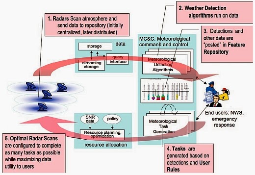 Flow diagram depicting the major processing steps of the closed-loop software architecture
Abstract. Dense networks of short-range radars capable of mapping storms and detecting atmospheric hazards are described. Composed of small X-band (9.4 GHz) radars spaced tens of kilometers apart, these networks defeat the Earth curvature blockage that limits today's long-range weather radars and enables observing capabilities fundamentally beyond the operational state-of-the-art radars. These capabilities include multiple Doppler observations for mapping horizontal wind vectors, subkilometer spatial resolution, and rapid-update (tens of seconds) observations extending from the boundary layer up to the tops of storms. The small physical size and low-power design of these radars permits the consideration of commercial electronic manufacturing approaches and radar installation on rooftops, communications towers, and other infrastructure elements, leading to cost-effective network deployments. The networks can be architected in such a way that the sampling strategy dynamically responds to changing weather to simultaneously accommodate the data needs of multiple types of end users. Such networks have the potential to supplement, or replace, the physically large long-range civil infrastructure radars in use today.
Monday, September 29, 2008
Three-Dimensional Motion Estimation of Atmospheric Layers From Image Sequences
In this paper, we address the problem of estimating 3-D motions of a stratified atmosphere from satellite image sequences. The analysis of 3-D atmospheric fluid flows associated with incomplete observation of atmospheric layers due to the sparsity of cloud systems is very difficult. This makes the estimation of dense atmospheric motion field from satellite image sequences very difficult. The recovery of the vertical component of fluid motion from a monocular sequence of image observations is a very challenging problem for which no solution exists in the literature. Based on a physically sound vertical decomposition of the atmosphere into cloud layers of different altitudes, we propose here a dense motion estimator dedicated to the extraction of 3-D wind fields characterizing the dynamics of a layered atmosphere. Wind estimation is performed over the complete 3-D space, using a multilayer model describing a stack of dynamic horizontal layers of evolving thickness, interacting at their boundaries via vertical winds. The efficiency of our approach is demonstrated on synthetic and real sequences. - Reference
Wednesday, August 27, 2008
Polarization isolation requirements for linear dual-polarization weather Radar in simultaneous transmission mode of operation
Yanting Wang; Chandrasekar, V., "Polarization isolation requirements for linear dual-polarization weather Radar in simultaneous transmission mode of operation," IEEE Transactions on Geoscience and Remote Sensing, vol.44, no.8, pp.2019 - 2028, Aug. 2006. doi: 10.1109/TGRS.2006.872138
Abstract: A dual-polarization radar system operating in simultaneous transmission mode of both horizontal and vertical polarization states is a viable implementation if only copolar measurements are needed. The simultaneous transmission of horizontal and vertical polarizations results in an arbitrary elliptical polarization state transmitted, whereas the reception states in horizontal and vertical polarizations are neither copolar nor cross-polar to the transmitted state. Because of this, it is often referred as the hybrid mode. Previous studies have shown that the hybrid mode in the linear horizontal and vertical polarization basis is capable of providing measurements similar to the alternate transmission mode for most measurement conditions. These findings are based on the assumption of perfect sensing systems. This paper presents the results of radar system limitations on hybrid mode measurements that in turn are converted to system requirements. It is shown that the polarization purity requirement is more stringent for the hybrid mode compared to the alternate mode of operation
URL: http://ieeexplore.ieee.org/stamp/stamp.jsp?tp=&arnumber=1661791&isnumber=34774
Subscribe to:
Posts (Atom)