Showing posts with label Wind field estimation. Show all posts

Tuesday, August 19, 2014

National Weather Service in Raleigh debuts faster Doppler radar

Meteorologists at the National Weather Service in Raleigh recently got an upgrade to their Doppler radar, giving them more data and quicker updates when the weather turns severe.

The upgrade, called SAILS, or Supplemental Adaptive Intra-Volume Low-Level Scan, allows the meteorologists to get radar images from the lowest part of the storm every 2 minutes instead of every 4.

“More frequent updates of what's going on near the ground gives us a better idea of what's about to hit the ground or impact the ground,” said NWS meteorologist Jonathan Blaes.

Blaes says the radar does more than just show where it’s raining. “It scans at multiple slices to get a 3D view of precipitation, thunderstorms and other phenomena,” he said.

Seeing what's happening inside a storm gives forecasters an idea of how dangerous it is and can tell them if a tornado is forming.

“The more observations you can get the closer to where people live, that's always helpful,” WRAL Chief Meteorologist Greg Fishel said.

WRAL’s DUALDoppler5000 radar scans the lowest layer of the atmosphere once every minute. That radar, along with the Weather Service's newly upgraded Doppler radar, gives forecasters a better chance of spotting dangerous storms. That helps them issue better warnings and save more lives.
“More data is always better, and that's what we're excited about,” Fishel said.

The National Weather Service radar upgrade is in place now, ready for the next severe weather season, which typically happens in the fall. Another upgrade is planned within the next year to allow even more frequent updates.

The National Weather Service is working on a new kind of radar system, already used in the military, called Phased Array Radar. It will scan in less than one minute and cost less to operate. It likely will be a decade before those radars are installed, Blaes said.

Source

Friday, August 15, 2014

Radar software may fix weather forecast issues caused by wind farms

The movement of wind turbine propellers can mimic weather when viewed by the Doppler radar used by Environment Canada to predict storms.

The movement of wind turbine propellers can mimic weather when viewed by the Doppler radar used by Environment Canada to predict storms. (Robert F. Bukaty/Associated Press)

Environment Canada is preparing to roll out new radar technology in order to combat wind farm clutter, which clouds weather forecasts, misleads meteorologists and can even block radar signals.

Jim Young, who works at the agency's national radar program, said new software will be incorporated into Canada's radar system this fall in an effort to address the "contamination" caused by wind turbines.

Tuesday, August 12, 2014

Environment Canada testing radar software to combat wind farm clutter

Wind turbines are shown in this file photo. (The Canadian Press/Dave Chidley)

Wind turbines are shown in this file photo. (The Canadian Press/Dave Chidley)

Clare Clancy, The Canadian Press Published Sunday, August 10, 2014 9:20AM EDT

TORONTO -- Environment Canada is preparing to roll out new radar technology in order to combat wind farm clutter, which clouds weather forecasts, misleads meteorologists and can even block radar signals.

Jim Young, who works at the agency's national radar program, said new software will be incorporated into Canada's radar system this fall in an effort to address the "contamination" caused by wind turbines.

"I certainly have very high hopes," he said, adding that Environment Canada has been concerned about wind farm clutter for years.

The agency uses Doppler radar to predict storms, but the movement of wind turbine propellers can mimic weather.

Tuesday, July 8, 2014

Change in NWS Doppler Radar Scanning Strategy Will Provide Much Needed Data and Should Lead to Improved Warnings

A new software upgrade installed at the National Weather Service (NWS) Raleigh Doppler radar (KRAX) today, July 8th, is expected to have a significant impact in severe weather operations. Around two-thirds of all NWS Doppler radars have been upgraded as of today, with the rest likely occurring during the next few months. You can view the current build of each NWS radar here (radar’s with the upgrade have the RPG build listed as “14.1”). The software change will allow the WSR-88D radar to obtain the lowest level radar scan more frequently during severe weather events.

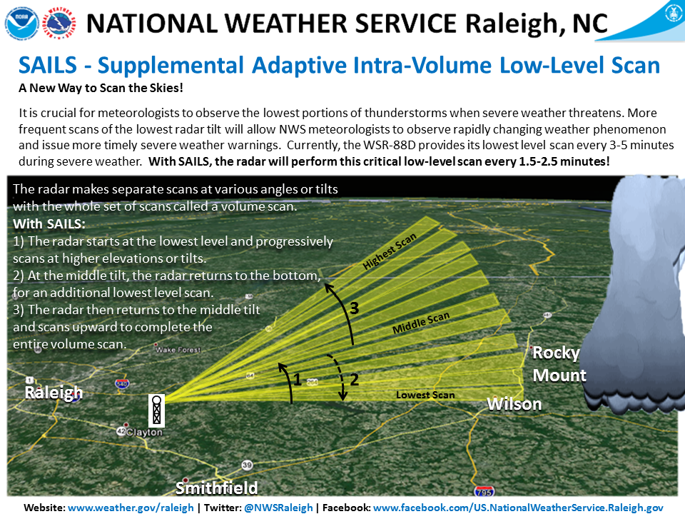
With this upgrade, a new feature called SAILS (Supplemental Adaptive Intra-Volume Low-Level Scan) will enable the radar to insert an additional 0.5 degree scan in the middle of a volume scan (see the illustration below for more details). Currently, the WSR-88D radar completes its lowest scan in 3 to 4.3 minutes (during severe weather), depending on the range of the storms from the radar. With SAILS, the radar can now perform this low-level scan every 1.9 to 2.5 minutes, obtaining a 0.5 degree scan almost twice as frequently as before and providing NWS meteorologists with the ability to observe rapidly changing weather phenomenon more frequently and issue more timely severe weather warnings.

A training presentation was provided to NWS Raleigh partners detailing some of the changes with the build, it can be accessed here.  The Warning Decision Training Branch (WDTB) has other training resources that are available online as well – RDA/RPG Build 14.0/RPG Build 14.1 training.

RAH.SAILS.infographic

Source

Monday, September 29, 2008

Three-Dimensional Motion Estimation of Atmospheric Layers From Image Sequences

In this paper, we address the problem of estimating 3-D motions of a stratified atmosphere from satellite image sequences. The analysis of 3-D atmospheric fluid flows associated with incomplete observation of atmospheric layers due to the sparsity of cloud systems is very difficult. This makes the estimation of dense atmospheric motion field from satellite image sequences very difficult. The recovery of the vertical component of fluid motion from a monocular sequence of image observations is a very challenging problem for which no solution exists in the literature. Based on a physically sound vertical decomposition of the atmosphere into cloud layers of different altitudes, we propose here a dense motion estimator dedicated to the extraction of 3-D wind fields characterizing the dynamics of a layered atmosphere. Wind estimation is performed over the complete 3-D space, using a multilayer model describing a stack of dynamic horizontal layers of evolving thickness, interacting at their boundaries via vertical winds. The efficiency of our approach is demonstrated on synthetic and real sequences. - Reference