Showing posts with label Wind turbines. Show all posts

Friday, August 15, 2014

Radar software may fix weather forecast issues caused by wind farms

The movement of wind turbine propellers can mimic weather when viewed by the Doppler radar used by Environment Canada to predict storms.

The movement of wind turbine propellers can mimic weather when viewed by the Doppler radar used by Environment Canada to predict storms. (Robert F. Bukaty/Associated Press)

Environment Canada is preparing to roll out new radar technology in order to combat wind farm clutter, which clouds weather forecasts, misleads meteorologists and can even block radar signals.

Jim Young, who works at the agency's national radar program, said new software will be incorporated into Canada's radar system this fall in an effort to address the "contamination" caused by wind turbines.

Tuesday, August 12, 2014

Environment Canada testing radar software to combat wind farm clutter

Wind turbines are shown in this file photo. (The Canadian Press/Dave Chidley)

Wind turbines are shown in this file photo. (The Canadian Press/Dave Chidley)

Clare Clancy, The Canadian Press Published Sunday, August 10, 2014 9:20AM EDT

TORONTO -- Environment Canada is preparing to roll out new radar technology in order to combat wind farm clutter, which clouds weather forecasts, misleads meteorologists and can even block radar signals.

Jim Young, who works at the agency's national radar program, said new software will be incorporated into Canada's radar system this fall in an effort to address the "contamination" caused by wind turbines.

"I certainly have very high hopes," he said, adding that Environment Canada has been concerned about wind farm clutter for years.

The agency uses Doppler radar to predict storms, but the movement of wind turbine propellers can mimic weather.

Thursday, March 13, 2014

New radar technology to free-up radio spectrum

New radar technology could help free up highly sought after radio spectrum currently used for air traffic surveillance.
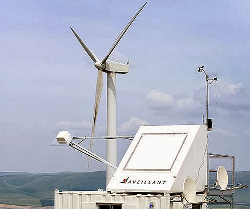
Aveillant's 3D Holographic Radar claims to mitigate the disruptive effect of wind farms on radar

The government has tasked the Civil Aviation Authority (CAA) with investigating options that would allow it to release bandwidth in the current air traffic radar spectrum allocation – in the ‘S Band’ between 2.7 and 2.9 GHz – to help meet its aspiration to free up 500 MHz of public spectrum by 2020.

In response, Cambridge technology firm Aveillant has been awarded a contract by the CAA to demonstrate the ability of its Holographic Radar technology to provide a spectrum-efficient alternative to S-band radar.

At present each radar typically has its own frequency assignment, but Aveillant hopes to demonstrate a surveillance system that can enable all air traffic control radars in the UK to operate through a single frequency assignment, separate from the ‘S Band’.

The firm’s radars use the L band frequency as opposed to the highly congested S band, used by current air traffic control radars and highly sought after by mobile phone operators.

Gordon Oswald, chief technology officer at Aveillant, said: “This is not a simple problem to solve, but based on our experience with Holographic Radar we’re confident that we are best placed to do so.

“Air traffic control radars cannot be simply shifted to another frequency, such as L band: this would then itself become too congested. At the same time, a much higher frequency is less suitable for long-range air traffic control radar due to atmospheric effects.

“This problem is ripe for a solution that changes the way air traffic radars occupy bandwidth. It’s going to be a demanding project to show how this solution will work – but one that we’re well equipped to handle.”

According to the firm, its 3D Holographic Radar is also proven to successfully mitigate the effect of wind farms on radar and has excelled in trials held by US and UK aviation stakeholders.

Source

Tuesday, March 4, 2014

Civil Aviation Authority trials Cambridge radar

The UK’s Civil Aviation Authority (CAA) is using novel radar technology from Cambridge business, Aveillant.

Aveillant CTO, Gordon OswaldIt has awarded a contract to the company to demonstrate the ability of its Holographic RadarTM technology to provide a spectrum-efficient alternative to S-band primary air traffic surveillance radar.

The UK government aspires to release 500 MHz of public spectrum by 2020 and has tasked the CAA with investigating the viability of options to release bandwidth in the current air traffic radar spectrum allocation in the ‘S Band’ between 2.7 and 2.9 GHz.

The CAA is investigating two options: to change and reduce the spectrum occupied by existing aerodrome radars, and to exploit new, spectrum efficient solutions that have potential to provide additional benefits to aviation.

Monday, May 20, 2013

U.S. Finishes Wind Turbine Radar Interference Trials

The FAA and other U.S. government agencies have completed the third and final operational field test in a two-year, $8 million program to study the physical and electromagnetic interference between radar systems and wind turbine farms, and to identify mitigation techniques to address this issue.

Data from the third Interagency Field Test and Evaluation of Wind Turbine-Radar (IFT&E), designed to assess near-term mitigation and to help develop long-term mitigation techniques, is being analyzed by Sandia National Laboratories and the Massachusetts Institute of Technology Lincoln Laboratory. The test took place in April.

Interference with radar has been a safety concern for both the FAA and the military, as well as a key roadblock to developers of new wind turbine farms, both in the U.S. and abroad.

Energy needs are accelerating plans for new wind farms, and elevating the priority for finding mitigation measures for radar interference. According to the U.S. Department of Energy (DOE), since 2000 wind power-generation capacity in the U.S. has increased from 5 gigawatts to 60, and could increase to as much as 305 gigawatts by 2030, supplying about 20% of U.S. electricity needs.

Friday, March 26, 2010

Range-Doppler Imaging of Rotating Objects

Walker, Jack L., "Range-Doppler Imaging of Rotating Objects," Aerospace and Electronic Systems, IEEE Transactions on , vol.AES-16, no.1, pp.23,52, Jan. 1980
doi: 10.1109/TAES.1980.308875

Abstract: During the integration time required to obtain fine Dopplerfrequency resolution in a range-Doppler imaging radar, a point on a rotating object may move through several range and Doppler resolution cells and produce a smeared image. This motion can be compensated by storing the appropriately processed return pulse, and the angular coordinates are determined by the angular coordinates of the radar antenna. The resulting stored data represents the three-dimensional Fourier transform of the object reflectivity density, and hence can be processed by an inverse Fourier transformation. Also included is an analysis of the three-dimensional radar/object geometry with separate source and receiver locations. The effects of various system aberrations are investigated and experimental results from a microwave test range which demonstrate the image improvement are presented.

Reference