Showing posts with label WSR-88D. Show all posts

Tuesday, July 8, 2014

Change in NWS Doppler Radar Scanning Strategy Will Provide Much Needed Data and Should Lead to Improved Warnings

A new software upgrade installed at the National Weather Service (NWS) Raleigh Doppler radar (KRAX) today, July 8th, is expected to have a significant impact in severe weather operations. Around two-thirds of all NWS Doppler radars have been upgraded as of today, with the rest likely occurring during the next few months. You can view the current build of each NWS radar here (radar’s with the upgrade have the RPG build listed as “14.1”). The software change will allow the WSR-88D radar to obtain the lowest level radar scan more frequently during severe weather events.

With this upgrade, a new feature called SAILS (Supplemental Adaptive Intra-Volume Low-Level Scan) will enable the radar to insert an additional 0.5 degree scan in the middle of a volume scan (see the illustration below for more details). Currently, the WSR-88D radar completes its lowest scan in 3 to 4.3 minutes (during severe weather), depending on the range of the storms from the radar. With SAILS, the radar can now perform this low-level scan every 1.9 to 2.5 minutes, obtaining a 0.5 degree scan almost twice as frequently as before and providing NWS meteorologists with the ability to observe rapidly changing weather phenomenon more frequently and issue more timely severe weather warnings.

A training presentation was provided to NWS Raleigh partners detailing some of the changes with the build, it can be accessed here.  The Warning Decision Training Branch (WDTB) has other training resources that are available online as well – RDA/RPG Build 14.0/RPG Build 14.1 training.
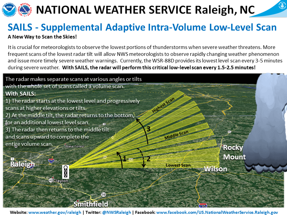
RAH.SAILS.infographic

Source

Thursday, July 19, 2012

Lifting the Fog: A Brief History of Radar

One of the worst airplane disasters in history occurred as a consequence of a series of unfortunate events. The location of the disaster was the island of Tenerife, the largest and most populated island of the Canary Islands, on March 27th, 1977. Two Boeing 747 planes prepared for departure on a crowded runway where they were instructed to follow a procedure called “backtaxi” where a portion of the runway is used as a taxiway for aircraft to taxi in the opposite direction from which they will take off. Through a series of misinterpreted communications between air traffic controllers and the pilots, one of the planes began their take off before the other, backtaxiing plane had cleared the same runway. Dense fog shrouded the planes from sight and they did not realize that they were barreling towards disaster until they were 2,000 feet from each other. A detailed account of the events of this fateful day can be found here.

Computer rendering of the Tenerife disaster. Source: http://www.nycaviation.com

Of all the events that led up to the disaster, the straw that broke the camel’s back was a dense layer of fog that clouded the two planes from each others', and the air traffic controller’s, vision. Unfortunately, the small airport on Tenerife was not equipped with ground-based radar, a tool that would have allowed the controllers to see the location of the planes even with the heavy cover of fog. Although this disaster happened 35 years ago, ground-based radar technology was already available, in fact, this technology was developed long before 1977.