Showing posts with label JPL. Show all posts

Sunday, March 9, 2014

NASA could predict sinkholes with space radar

NASA announced Friday that it may have found a way to predict sinkholes up to a month before they occur. The warning would be provided by interferometric synthetic aperture radar (iSAR), which could be placed on satellites or planes to scan areas prone to sinkholes.
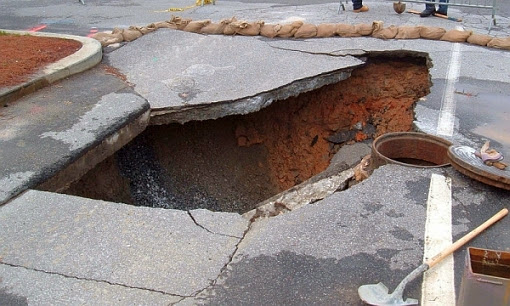
NASA may be able to use interferometric synthetic aperture radar (iSAR) to predict sinkholes up to a month before they occur. Sinkholes are depressions in the ground formed when layers of the earth's surface fall into underground caverns. Usually they form without warning. (Photo : Scott Ehardt | Wikimedia Commons)

iSAR scans the ground several times in several different wavelengths to put together interferograms, which can show small movements of the Earth such as the effect of flooding on riverbanks, the ripples of earthquakes and where the ground is sinking.

Sinkholes are depressions in the ground formed when layers of the earth's surface fall into underground caverns. Usually they form without warning.

Friday, October 5, 2007

Cassini RADAR view of Titan's north pole

Cassini RADAR mosaic view of Titan's north pole

This mosaic is composed of all synthetic-aperture-radar maps of Titan's polar regions acquired by Cassini to date. It has been cropped and reduced in size by 50% from an even larger mosaic available on NASA's Planetary Photojournal. Approximately 60 percent of Titan's northern polar region (poleward of 60 degrees north latitude) has been mapped as of October 2007, and of this area, about 14% appears to be covered with hydrocarbon lakes. The radar images are grayscale; they have been colored here with a color map that applies blue colors to the materials that are darkest to the RADAR instrument, and yellow colors to the materials that are brightest. This color scheme highlights the apparent lakes, but also shows that many lake-like features are not as dark as other lakes, and that darker channels appear to run down the interiors of less dark lakes.

The image is a polar projection, with zero longitude (the sub-Saturnian hemisphere) toward the bottom. The leading hemisphere (centered at 90 degrees W) is to the left, and the trailing hemisphere (centered at 270 degrees W) is to the right. The largest lakes are clustered in an area on Titan's trailing hemisphere.

NASA / JPL-Caltech