Showing posts with label Remote Sensing. Show all posts

Tuesday, August 26, 2014

G band atmospheric radars: new frontiers in cloud physics

A. Battaglia1, C. D. Westbrook2, S. Kneifel3, P. Kollias3, N. Humpage1, U. Löhnert4, J. Tyynelä5, and G. W. Petty6

  • 1Department of Physics and Astronomy, University of Leicester, University Road, Leicester, UK
  • 2Department of Meteorology, University of Reading, Reading, UK
  • 3McGill University, Montreal, Canada
  • 4Institut für Geophysik und Meteorologie, University of Cologne, Cologne, Germany
  • 5Department of Physics, University of Helsinki, Helsinki, Finland
  • 6University of Wisconsin-Madison, Madison, Wisconsin, USA

Abstract. Clouds and associated precipitation are the largest source of uncertainty in current weather and future climate simulations. Observations of the microphysical, dynamical and radiative processes that act at cloud scales are needed to improve our understanding of clouds. The rapid expansion of ground-based super-sites and the availability of continuous profiling and scanning multi-frequency radar observations at 35 and 94 GHz have significantly improved our ability to probe the internal structure of clouds in high temporal-spatial resolution, and to retrieve quantitative cloud and precipitation properties. However, there are still gaps in our ability to probe clouds due to large uncertainties in the retrievals.

The present work discusses the potential of G band (frequency between 110 and 300 GHz) Doppler radars in combination with lower frequencies to further improve the retrievals of microphysical properties. Our results show that, thanks to a larger dynamic range in dual-wavelength reflectivity, dual-wavelength attenuation and dual-wavelength Doppler velocity (with respect to a Rayleigh reference), the inclusion of frequencies in the G band can significantly improve current profiling capabilities in three key areas: boundary layer clouds, cirrus and mid-level ice clouds, and precipitating snow.

Citation: Battaglia, A., Westbrook, C. D., Kneifel, S., Kollias, P., Humpage, N., Löhnert, U., Tyynelä, J., and Petty, G. W.: G band atmospheric radars: new frontiers in cloud physics, Atmos. Meas. Tech., 7, 1527-1546, doi:10.5194/amt-7-1527-2014, 2014.

Wednesday, April 16, 2014

Python-3 Ground Penetrating Radar

Wireless Monostatic Ground Penetrating Radar with one receiving-transmitting antenna Python-3.

4 frequency modules (25, 38, 50, 100 MHz) of the Python-3  - Wireless Monostatic Ground Penetrating Radar with one receiving-transmitting antenna4 frequency modules (25, 38, 50, 100 MHz) of the Python-3  - Wireless Monostatic Ground Penetrating Radar with one receiving-transmitting antenna

Features

  • FREQUENCES: 100 / 50 / 38 / 25 MHz
  • ANTENNA LENGTH: from 1 m to 4 m, depends on selected frequency
  • WEIGHT: from 10 kg to 20 kg, depends on selected frequency
  • TIME RANGE: from 1 to 1500 ns, step 1 ns
  • SCAN RATE: 28 scans per second
  • SAMPLES PER SCAN: 1024 samples per scan
  • RESOLUTION: 16 bit
  • FILTERS: Preset and Customized digital filters.
  • GAIN: 9 points digital gain function
  • DATA TRANSFER: through built-in Wi-Fi to PC.
  • POWER: Built-in battery 12 V, 9 A*h with battery life more than 7 h
Python-3 georadar is a portable digital subsurface sounding radar carried by a single operator, especially used for deep surveys (up to 50 meters* in favorable ground). The unit is designed for solving a long-range of geotechnical, geological, engineering and other tasks wherever nondestructive operational environmental monitoring is needed. In the sounding process, the operator is getting real-time information as a radiolocation profile (sometimes also referred to as radargram) on a display. At the same time, data are recorded on a hard disc for further use (processing, printout, interpretation, etc.). Examples of radiolocation profiles you can see below.

Sunday, March 9, 2014

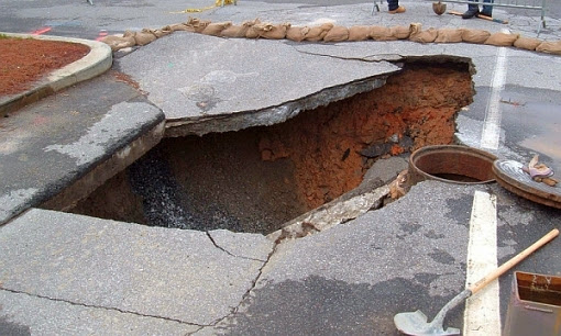
NASA could predict sinkholes with space radar

NASA announced Friday that it may have found a way to predict sinkholes up to a month before they occur. The warning would be provided by interferometric synthetic aperture radar (iSAR), which could be placed on satellites or planes to scan areas prone to sinkholes.

NASA may be able to use interferometric synthetic aperture radar (iSAR) to predict sinkholes up to a month before they occur. Sinkholes are depressions in the ground formed when layers of the earth's surface fall into underground caverns. Usually they form without warning. (Photo : Scott Ehardt | Wikimedia Commons)

iSAR scans the ground several times in several different wavelengths to put together interferograms, which can show small movements of the Earth such as the effect of flooding on riverbanks, the ripples of earthquakes and where the ground is sinking.

Sinkholes are depressions in the ground formed when layers of the earth's surface fall into underground caverns. Usually they form without warning.

Saturday, August 3, 2013

Radar-radiometer retrievals of cloud number concentration and dispersion parameter in nondrizzling marine stratocumulus


J. Rémillard1,*, P. Kollias1, and W. Szyrmer1

  • 1Department of Atmospheric and Oceanic Sciences, McGill University, Montreal, QC, Canada
  • *currently at: Department of Applied Physics and Applied Mathematics, Columbia University, New York, USA

Abstract. The retrieval of cloud microphysical properties from remote sensors is challenging. In the past, ground-based radar-radiometer measurements have been successfully used to retrieve the liquid water content profile in nondrizzling clouds but offer little constraint in retrieving other moments of the cloud particle size distribution (PSD). Here, a microphysical condensational model under steady-state supersaturation conditions is utilized to provide additional constraints to the well-established radar-radiometer retrieval techniques. The coupling of the model with the observations allows the retrieval of the three parameters of a lognormal PSD, with two of them being height dependent. Two periods of stratocumulus from the Azores are used to evaluate the novel technique. The results appear reasonable in two nondrizzling periods: continental-like number concentrations are retrieved, in agreement with the drizzle-free cloud conditions. The cloud optical depth derived from the retrieved distributions compares well in magnitude and variability with the one derived independently from a narrow field of view zenith radiometer. Uncertainties coming from the measurements are propagated to the retrieved quantities to estimate their errors. In general, errors smaller than 20% should be attainable for most parameters, demonstrating the added value of the new technique.

Citation: Rémillard, J., Kollias, P., and Szyrmer, W.: Radar-radiometer retrievals of cloud number concentration and dispersion parameter in nondrizzling marine stratocumulus, Atmos. Meas. Tech., 6, 1817-1828, doi:10.5194/amt-6-1817-2013, 2013.