Showing posts with label Journal article. Show all posts

Tuesday, August 26, 2014

G band atmospheric radars: new frontiers in cloud physics

A. Battaglia1, C. D. Westbrook2, S. Kneifel3, P. Kollias3, N. Humpage1, U. Löhnert4, J. Tyynelä5, and G. W. Petty6

  • 1Department of Physics and Astronomy, University of Leicester, University Road, Leicester, UK
  • 2Department of Meteorology, University of Reading, Reading, UK
  • 3McGill University, Montreal, Canada
  • 4Institut für Geophysik und Meteorologie, University of Cologne, Cologne, Germany
  • 5Department of Physics, University of Helsinki, Helsinki, Finland
  • 6University of Wisconsin-Madison, Madison, Wisconsin, USA

Abstract. Clouds and associated precipitation are the largest source of uncertainty in current weather and future climate simulations. Observations of the microphysical, dynamical and radiative processes that act at cloud scales are needed to improve our understanding of clouds. The rapid expansion of ground-based super-sites and the availability of continuous profiling and scanning multi-frequency radar observations at 35 and 94 GHz have significantly improved our ability to probe the internal structure of clouds in high temporal-spatial resolution, and to retrieve quantitative cloud and precipitation properties. However, there are still gaps in our ability to probe clouds due to large uncertainties in the retrievals.

The present work discusses the potential of G band (frequency between 110 and 300 GHz) Doppler radars in combination with lower frequencies to further improve the retrievals of microphysical properties. Our results show that, thanks to a larger dynamic range in dual-wavelength reflectivity, dual-wavelength attenuation and dual-wavelength Doppler velocity (with respect to a Rayleigh reference), the inclusion of frequencies in the G band can significantly improve current profiling capabilities in three key areas: boundary layer clouds, cirrus and mid-level ice clouds, and precipitating snow.

Citation: Battaglia, A., Westbrook, C. D., Kneifel, S., Kollias, P., Humpage, N., Löhnert, U., Tyynelä, J., and Petty, G. W.: G band atmospheric radars: new frontiers in cloud physics, Atmos. Meas. Tech., 7, 1527-1546, doi:10.5194/amt-7-1527-2014, 2014.

Monday, March 10, 2014

WegenerNet: A Pioneering High-Resolution Network for Monitoring Weather and Climate

Gottfried Kirchengast, Thomas Kabas, Armin Leuprecht, Christoph Bichler, and Heimo Truhetz, 2014: WegenerNet: A Pioneering High-Resolution Network for Monitoring Weather and Climate. Bull. Amer. Meteor. Soc., 95, 227–242.
doi: http://dx.doi.org/10.1175/BAMS-D-11-00161.1

The Feldbach region in southeast Austria, characteristic for experiencing a rich variety of weather and climate patterns, has been selected as the focus area for a pioneering weather and climate observation network at very high resolution: The WegenerNet comprises 151 meteorological stations measuring temperature, precipitation, and other parameters, in a tightly spaced grid within an area of about 20 km × 15 km centered near the city of Feldbach (46.93°N, 15.90°E). With its stations about every 2 km2, each with 5-min time sampling, the network provides regular measurements since January 2007, after a pilot phase, until 2010, meanwhile in an operational manner. Quality-controlled station time series and gridded field data (spacing 200 m × 200 m) are available in near–real time (data latency less than 1–2 h) for visualization and download via a data portal (www.wegenernet.org; detailed information is available via www.wegcenter.at/wegenernet).

The WegenerNet region in southeast Austria

This paper introduces the WegenerNet from its design and setup via its processing system and data products to showing example results. The latter include extreme weather event examples, climate variability over the 5-yr period from 2007 to 2011, and an example of calibration support to coupled climate–hydrology modeling. The network is set to serve as a long-term monitoring and validation facility for weather and climate research and applications. Uses include validation of nonhydrostatic models operated at 1-km-scale resolution and of statistical downscaling techniques (in particular for precipitation), validation of weather radar and satellite data, study of orography–climate relationships, and many others.

Thursday, January 23, 2014

Ancient Stone Bridge Surveying by Ground-Penetrating Radar and Numerical Modeling Methods

Solla, M., Riveiro, B., Lorenzo, H., and Armesto, J. (2014). ”Ancient Stone Bridge Surveying by Ground-Penetrating Radar and Numerical Modeling Methods.” J. Bridge Eng., 19(1), 110–119.

Bridges are considered necessary engineering structures because they connect separated lands to improve economic and social development. In Spain, many of the bridges in service within the network of transport are masonry arch bridges built in ancient times. In addition to their age, the stability of these remaining bridges is questionable because of the changing loading conditions; therefore, they require periodic assessment of the condition state. Moreover, some of these bridges are considered a part of the cultural heritage of a region, so nondestructive evaluation is required to preserve their historical character. In this work, a medieval stone bridge in the Galician territory of Spain was evaluated using ground-penetrating radar, supported by a detailed geometric survey performed through a terrestrial laser scanner. The results revealed unknown geometrical data and hidden characteristics, including the thickness of ring stones in the interior of the vault, as well as the presence of ancient arches and restorations. To assist in the interpretation, finite-difference time-domain modeling was used, where realistic models were built from the accurate geometry provided. The synthetic data obtained were compared with the field data, which allowed for the identification of unknown structural details.

Source

Saturday, August 3, 2013

Radar-radiometer retrievals of cloud number concentration and dispersion parameter in nondrizzling marine stratocumulus


J. Rémillard1,*, P. Kollias1, and W. Szyrmer1

  • 1Department of Atmospheric and Oceanic Sciences, McGill University, Montreal, QC, Canada
  • *currently at: Department of Applied Physics and Applied Mathematics, Columbia University, New York, USA

Abstract. The retrieval of cloud microphysical properties from remote sensors is challenging. In the past, ground-based radar-radiometer measurements have been successfully used to retrieve the liquid water content profile in nondrizzling clouds but offer little constraint in retrieving other moments of the cloud particle size distribution (PSD). Here, a microphysical condensational model under steady-state supersaturation conditions is utilized to provide additional constraints to the well-established radar-radiometer retrieval techniques. The coupling of the model with the observations allows the retrieval of the three parameters of a lognormal PSD, with two of them being height dependent. Two periods of stratocumulus from the Azores are used to evaluate the novel technique. The results appear reasonable in two nondrizzling periods: continental-like number concentrations are retrieved, in agreement with the drizzle-free cloud conditions. The cloud optical depth derived from the retrieved distributions compares well in magnitude and variability with the one derived independently from a narrow field of view zenith radiometer. Uncertainties coming from the measurements are propagated to the retrieved quantities to estimate their errors. In general, errors smaller than 20% should be attainable for most parameters, demonstrating the added value of the new technique.

Citation: Rémillard, J., Kollias, P., and Szyrmer, W.: Radar-radiometer retrievals of cloud number concentration and dispersion parameter in nondrizzling marine stratocumulus, Atmos. Meas. Tech., 6, 1817-1828, doi:10.5194/amt-6-1817-2013, 2013.

Monday, April 15, 2013

Cognitive Radar Network: Cooperative Adaptive Beamsteering for Integrated Search-and-Track Application

Romero, R.A.; Goodman, N.A., "Cognitive Radar Network: Cooperative Adaptive Beamsteering for Integrated Search-and-Track Application," Aerospace and Electronic Systems, IEEE Transactions on , vol.49, no.2, pp.915,931, APRIL 2013
doi: 10.1109/TAES.2013.6494389

Abstract: Cognitive radar (CR) is a paradigm shift from a traditional radar system in that previous knowledge and current measurements obtained from the radar channel are used to form a probabilistic understanding of its environment. Moreover, CR incorporates this probabilistic knowledge into its task priorities to form illumination and probing strategies, thereby rendering it a closed-loop system. Depending on the hardware's capabilities and limitations, there are various degrees of freedom that a CR may utilize. Here we concentrate on spatial illumination as a resource, where adaptive beamsteering is used for search-and-track functions. We propose a multiplatform cognitive radar network (CRN) for integrated search-and-track application. Specifically, two radars cooperate in forming a dynamic spatial illumination strategy, where beamsteering is matched to the channel uncertainty to perform the search function. Once a target is detected and a track is initiated, track information is integrated into the beamsteering strategy as part of CR's task prioritization.

Source

Thursday, June 7, 2012

An Extended Kalman Filter Framework for Polarimetric X-Band Weather Radar Data Processing

Marc Schneebeli and Alexis Berne, 2012: An Extended Kalman Filter Framework for Polarimetric X-Band Weather Radar Data Processing. J. Atmos. Oceanic Technol., 29, 711–730. doi: http://dx.doi.org/10.1175/JTECH-D-10-05053.1

Abstract The different quantities measured by dual-polarization radar systems are closely linked to each other. An extended Kalman filter framework is proposed in order to make use of constraints on individual radar observables that are induced by these relations. This new approach simultaneously estimates the specific differential phase on propagation Kdp, the attenuation-corrected reflectivity at horizontal polarization Zh, and the attenuation-corrected differential reflectivity Zdr, as well as the differential phase shift on backscatter δ. In a simulation experiment it is found that Kdp and δ can be retrieved with higher accuracy and spatial resolution than existing estimators that solely rely on a smoothed measurement of the differential phase shift Ψdp. Attenuation-corrected Zh was retrieved with an accuracy similar to standard algorithms, but improvements were found for attenuation-corrected Zdr. In addition, the algorithm can be used for radar calibration by comparing the directly retrieved differential phase shift on propagation Φdp with the accumulated Kdp estimates. The extended Kalman filter estimation scheme was applied to data collected with an X-band polarimetric radar in the Swiss Alps in 2010. Radome attenuation appears to be significant (up to 5 dB) in moderate to intense rain events and hence needs to be corrected in order to have reliable quantitative precipitation estimates. Measurements corrected for radome and propagation attenuation were converted into rain-rate R with a newly developed relation between R, Kdp, and Zdr. The good agreement between rain-rate values inferred from ground observations and from the radar measurements confirms the reliability of the proposed radar processing technique.

Saturday, March 26, 2011

A signal processing view of strip-mapping synthetic aperture radar

Munson, D.C., Jr.; Visentin, R.L., "A signal processing view of strip-mapping synthetic aperture radar," Acoustics, Speech and Signal Processing, IEEE Transactions on , vol.37, no.12, pp.2131,2147, Dec 1989. doi: 10.1109/29.45556

Abstract: The authors derive the fundamental strip-mapping SAR (synthetic aperture radar) imaging equations from first principles. They show that the resolution mechanism relies on the geometry of the imaging situation rather than on the Doppler effect. Both the airborne and spaceborne cases are considered. Range processing is discussed by presenting an analysis of pulse compression and formulating a mathematical model of he radar return signal. This formulation is used to obtain the airborne SAR model. The authors study the resolution mechanism and derive the signal processing relations needed to produce a high-resolution image. They introduce spotlight-mode SAR and briefly indicate how polar-format spotlight processing can be used in strip-mapping SAR. They discuss a number of current and future research directions in SAR imaging

Reference

Wide-angle radar imaging using time-frequency distributions

Lanterman, A.D.; Munson, D.C., Jr.; Wu, Y., "Wide-angle radar imaging using time-frequency distributions," Radar, Sonar and Navigation, IEE Proceedings - , vol.150, no.4, pp.203-11,, 1 Aug. 2003. doi: 10.1049/ip-rsn:20030712

Abstract: Low-frequency radar systems provide some attractive advantages in a few niche applications, such as foliage penetration and covert operation. In low-frequency imaging systems, data must be collected over a wide range of angles to obtain cross-range resolution comparable to that obtainable from a competing small-angle high-frequency system. The reflectivity of a target varies with aspect angle; although this variation is usually ignored by traditional radar imaging algorithms, it sometimes cannot be neglected in wide-angle scenarios. To account for aspect dependence of reflectivity, time-frequency transforms have been invoked to generate a series of images corresponding to different look angles; these images may be considered individually or synthesised into a single image. A simple theoretical analysis with a point scatterer illustrates why the angular dependence needs explicit consideration. The potential of time-frequency methods is illustrated via simulations

Reference

Saturday, November 27, 2010

Multifunction Phased-Array Radar: Time Balance Scheduler for Adaptive Weather Sensing

Ricardo Reinoso-Rondinel, Tian-You Yu, and Sebastián Torres, 2010: Multifunction Phased-Array Radar: Time Balance Scheduler for Adaptive Weather Sensing. J. Atmos. Oceanic Technol., 27, 1854–1867. doi: http://dx.doi.org/10.1175/2010JTECHA1420.1

Abstract. Phased-array radars (PARs) have the capability of instantaneously and dynamically controlling beam position on a pulse-by-pulse basis, which allows a single radar to perform multiple functions, such as tracking multiple storms or weather and aviation surveillance. Moreover, these tasks can be carried out with different update times to achieve the goal of better characterizing and forecasting the storms of interest. However, these tasks usually compete for finite radar resources, and scheduling algorithms are often needed to address resource contention. To capitalize on the PAR capabilities, an algorithm based on the concept of time balance (TB) is developed for adaptive weather sensing. Two quality measures are introduced to quantify the gain of adaptive sensing relative to standard scanning patterns used by the Weather Surveillance Radar-1988 Doppler (WSR-88D). A simulation experiment is performed to demonstrate the advantages of adaptive sensing and to test and verify the performance of the TB scheduling algorithm. It is shown that the gain of adaptive sensing can be realized by the TB scheduler; that is, storms of interest can be revisited more frequently within a relatively short period time compared to conventional scanning.

Friday, March 26, 2010

Range-Doppler Imaging of Rotating Objects

Walker, Jack L., "Range-Doppler Imaging of Rotating Objects," Aerospace and Electronic Systems, IEEE Transactions on , vol.AES-16, no.1, pp.23,52, Jan. 1980
doi: 10.1109/TAES.1980.308875

Abstract: During the integration time required to obtain fine Dopplerfrequency resolution in a range-Doppler imaging radar, a point on a rotating object may move through several range and Doppler resolution cells and produce a smeared image. This motion can be compensated by storing the appropriately processed return pulse, and the angular coordinates are determined by the angular coordinates of the radar antenna. The resulting stored data represents the three-dimensional Fourier transform of the object reflectivity density, and hence can be processed by an inverse Fourier transformation. Also included is an analysis of the three-dimensional radar/object geometry with separate source and receiver locations. The effects of various system aberrations are investigated and experimental results from a microwave test range which demonstrate the image improvement are presented.

Reference

Wednesday, March 24, 2010

Antenna Effects in Depolarization Measurements

Blanchard, A.J.; Jean, Buford Randall, "Antenna Effects in Depolarization Measurements," IEEE Transactions on Geoscience and Remote Sensing, vol.GE-21, no.1, pp.113,117, Jan. 1983, doi: 10.1109/TGRS.1983.350537

Abstract: The depolarization of electromagnetic energy scattered from natural terrain has been of interest to experimenters and theoreticians for many years. However, the reported measurements have not agreed with theoreticaly predicted results. Boresight axial ratio has commonly been used as a figure of merit to describe the polarization isolation properties of the measurement system antennas. Since depolarization measurements from terrain involve extended targets which fill the full antenna beam, boresight axial ratio is often an inadequate measure of antenna polarization purity. This paper describes antenna isolation characteristics which impact the quality of the depolarized measurements. Representative calculations demonstrate the effects of nonideal antenna systems on the observed measurements. A criterion for antenna specification is given which will provide high-quality cross-polarized measurements.

Source

Sunday, December 27, 2009

Short-Wavelength Technology and the Potential For Distributed Networks of Small Radar Systems

David McLaughlin, David Pepyne, Brenda Philips, James Kurose, Michael Zink, David Westbrook, Eric Lyons, Eric Knapp, Anthony Hopf, Alfred Defonzo, Robert Contreras, Theodore Djaferis, Edin Insanic, Stephen Frasier, V. Chandrasekar, Francesc Junyent, Nitin Bharadwaj, Yanting Wang, Yuxiang Liu, Brenda Dolan, Kelvin Droegemeier, Jerald Brotzge, Ming Xue, Kevin Kloesel, Keith Brewster, Frederick Carr, Sandra Cruz-Pol, Kurt Hondl, and Pavlos Kollias, 2009: Short-Wavelength Technology and the Potential For Distributed Networks of Small Radar Systems. Bull. Amer. Meteor. Soc., 90, 1797–1817. doi: http://dx.doi.org/10.1175/2009BAMS2507.1 -
http://journals.ametsoc.org/doi/abs/10.1175/2009BAMS2507.1

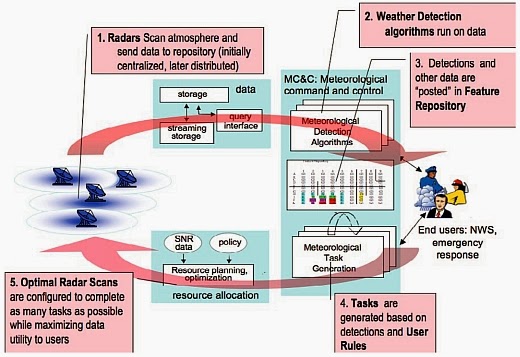
CASA project: Flow diagram depicting the major processing steps of the closed-loop software architectureFlow diagram depicting the major processing steps of the closed-loop software architecture

Abstract. Dense networks of short-range radars capable of mapping storms and detecting atmospheric hazards are described. Composed of small X-band (9.4 GHz) radars spaced tens of kilometers apart, these networks defeat the Earth curvature blockage that limits today's long-range weather radars and enables observing capabilities fundamentally beyond the operational state-of-the-art radars. These capabilities include multiple Doppler observations for mapping horizontal wind vectors, subkilometer spatial resolution, and rapid-update (tens of seconds) observations extending from the boundary layer up to the tops of storms. The small physical size and low-power design of these radars permits the consideration of commercial electronic manufacturing approaches and radar installation on rooftops, communications towers, and other infrastructure elements, leading to cost-effective network deployments. The networks can be architected in such a way that the sampling strategy dynamically responds to changing weather to simultaneously accommodate the data needs of multiple types of end users. Such networks have the potential to supplement, or replace, the physically large long-range civil infrastructure radars in use today.

Tuesday, February 17, 2009

High-Resolution Observations of Insects in the Atmospheric Boundary Layer

High spatial and temporal resolution S-band radar observations of insects in the atmospheric boundary layer (ABL) are described. The observations were acquired with a frequency-modulated continuous-wave (FMCW) radar during the 2002 International H20 Project (IHOP_2002) held in Oklahoma in the months of May and June 2002. During the observational period the boundary layer was convective with a few periods of rain. Rayleigh scattering from particulate scatterers (i.e., insects) dominates the return; however, Bragg scattering from refractive index turbulence is also significant, especially at the top of the afternoon boundary layer. There is a strong diurnal signal in the insect backscatter: minima in the morning and at dusk and maxima at night and midafternoon. Insect number densities and radar cross sections (RCSs) are calculated. The RCS values range from less than 10−12 m2 to greater than 10−7 m2 and likewise have a strong diurnal signal. These are converted to equivalent reflectivity measurements that would be reported by typical meteorological radars. The majority of reflectivity measurements from particulate scatterers ranges from −30 to −5 dBZ; however, intense point scatterers (>10 dBZ) are occasionally present. The results show that although insects provide useful targets for characterization of the clear-air ABL, the requirements for continuous monitoring of the boundary layer are specific to time of day and range from −20 dBZ in the morning to −10 to −5 dBZ in the afternoon and nocturnal boundary layer (NBL).- Reference

Friday, October 3, 2008

High-Resolution Radar Data Assimilation for Hurricane Isabel (2003) at Landfall

Assimilating observations from five WSR-88D radars into a mesoscale numerical weather prediction model improves the structure and intensity predictions of the landfalling hurricane. - Reference


in September 2008 issue of

Bulletin of the American Meteorological Society

Tuesday, September 30, 2008

An Evaluation of Two NEXRAD Wind Retrieval Methodologies and Their Use in Atmospheric Dispersion Models

Two entirely different methods for retrieving 3D fields of horizontal winds from Next Generation Weather Radar (NEXRAD) radial velocities have been evaluated using radar wind profiler measurements to determine whether routine wind retrievals would be useful for atmospheric dispersion model applications. The first method uses a physical algorithm based on four-dimensional variational data assimilation, and the second simpler method uses a statistical technique based on an analytic formulation of the background error covariance. Both methods can be run in near–real time, but the simpler method was executed about 2.5 times as fast as the four-dimensional variational method. The observed multiday and diurnal variations in wind speed and direction were reproduced by both methods below 1.5 km above the ground in the vicinity of Oklahoma City, Oklahoma, during July 2003. However, wind retrievals overestimated the strength of the nighttime low-level jet by as much as 65%. The wind speeds and directions obtained from both methods were usually similar when compared with profiler measurements, and neither method outperformed the other statistically. Within a dispersion model framework, the 3D wind fields and transport patterns were often better represented when the wind retrievals were included along with operational data. Despite uncertainties in the wind speed and direction obtained from the wind retrievals that are higher than those from remote sensing radar wind profilers, the inclusion of the wind retrievals is likely to produce more realistic temporal variations in the winds aloft than would be obtained by interpolation using the available radiosondes, especially during rapidly changing synoptic- and mesoscale conditions.- Reference

Maximum Position Alignment Method for Noisy High-Resolution Radar Target Classification

In this paper, the alignment of noisy high-resolution radar signals using the maximum position method is studied. The relationship between the shift estimation and the signal-to-noise ratio is considered. As a result, two analytical expressions are obtained that approximate the root-mean-square error of the difference in the shift estimation with and without noise. These two expressions allow us to improve the understanding of the sensitivity to noise of the Maximum Position alignment method. - Reference

Predicted Detection Performance of MIMO Radar

It has been shown that multiple-input multiple-output (MIMO) radar systems can improve target detection performance significantly by exploiting the spatial diversity gain. We introduce the system model in which the radar target is composed of a finite number of small scatterers and derive the formula to evaluate the theoretical probability of detection for the system having an arbitrary array-target configuration. The results can be used to predict the detection performance of the actual MIMO radar without time-consuming simulations. - Reference

Radar Revisited (review of "Radar Handbook, 3rd ed." by Merrill Skolnik) [Book Reviews]

This is the third edition of an established handbook, edited by one of the most-recognized names in the field of radar technology. The volume is a compilation of 26 chapters, authored by individuals with a thorough command of, and incredible credentials in, the topics of their chapters. Most chapters have a large number of figures (up to several dozen) and extensive bibliographies. Chapters range from fairly quantitative and mathematical ones to cursory and descriptive ones. Some sections of the handbook represent a concise and readable summary of the state-of-the-art of knowledge on their topics; others are a sketchy collection of remarks for which it is difficult to identify the benefits to be derived by the reader. There is little coordination between chapters where similar topics may be discussed, and a lack of any cross-referencing. There are also weaknesses in the index, as well. While the older, classical radar topics receive much attention, the book overlooks newer areas such as coverage of automotive radars. This volume will appeal to the generalists with interest in the conventional radar subjects, and to others as a starting point for locating sources with more detailed information. - Reference

An Orientation-Selective Orthogonal Lapped Transform

A novel critically sampled orientation-selective orthogonal lapped transform called the lapped Hartley transform (LHT) is derived. In a first step, overlapping basis functions are generated by modulating basis functions of a 2-D block Hartley transform by a cosine wave. To achieve invertibility and orthogonality, an iterative filter is applied as prefilter in the analysis and as postfilter in the synthesis operation, respectively. Alternatively, filtering can be restricted to analysis or synthesis, ending up with a biorthogonal transform (LHT-PR, LHT-PO). A statistical analysis based on a 4000-image data base shows that the LHT and LHT-PO have better redundancy removal properties than other block or lapped transforms. Finally, image compression and noise removal examples are given, showing the advantages of the LHT especially in images containing oriented textures. - Reference

Texture Analysis and Classification With Linear Regression Model Based on Wavelet Transform

The wavelet transform as an important multiresolution analysis tool has already been commonly applied to texture analysis and classification. Nevertheless, it ignores the structural information while capturing the spectral information of the texture image at different scales. In this paper, we propose a texture analysis and classification approach with the linear regression model based on the wavelet transform. This method is motivated by the observation that there exists a distinctive correlation between the sample images, belonging to the same kind of texture, at different frequency regions obtained by 2-D wavelet packet transform. Experimentally, it was observed that this correlation varies from texture to texture. The linear regression model is employed to analyze this correlation and extract texture features that characterize the samples. Therefore, our method considers not only the frequency regions but also the correlation between these regions. In contrast, the pyramid-structured wavelet transform (PSWT) and the tree-structured wavelet transform (TSWT) do not consider the correlation between different frequency regions. Experiments show that our method significantly improves the texture classification rate in comparison with the multiresolution methods, including PSWT, TSWT, the Gabor transform, and some recently proposed methods derived from these. - Reference