Tuesday, February 17, 2009

Clutter Suppression for Staggered PRT Waveforms

This paper presents a clutter suppression methodology for staggered pulse repetition time (PRT) observations. It is shown that spectral moments of precipitation echoes can be accurately estimated even in cases where clutter-to-signal ratios are high by using a parametric time domain method (PTDM).

Based on radar signal simulations, the accuracy of the proposed method is evaluated for various observation conditions. The performance of PTDM is demonstrated by the implementation of the staggered PRT at the Colorado State University–University of Chicago–Illinois State Water Survey (CSU–CHILL). Based on this study, it is found that the accuracy of the retrieval is comparable to the current state of the art methods applied to the uniformly sampled observations and that the estimated velocity is unbiased for the complete Nyquist range.- Reference
Effects of Multiple Scattering on Attenuation-Based Retrievals of Stratiform Rainfall from CloudSat

An attenuation-based method to retrieve vertical profiles of rainfall rates from height derivatives/gradients of CloudSat nadir-pointing W-band reflectivity measurements is discussed. This method takes advantage of the high attenuation of W-band frequency signals in rain and the low variability of nonattenuated reflectivity due to strong non-Rayleigh scattering from rain drops. The retrieval uncertainties could reach 40%–50%. The suggested method is generally applicable to rainfall rates (R) in an approximate range from about 2–3 to about 20–25 mm h−1. Multiple scattering noticeably affects the gradients of CloudSat measurements for R values greater than about 5 mm h−1. To avoid a retrieval bias caused by multiple-scattering effects, a special correction for retrievals is introduced. For rainfall rates greater than about 25 mm h−1, the influence of multiple scattering gets overwhelming, and the retrievals become problematic, especially for rainfalls with higher freezing-level altitudes. The attenuation-based retrieval method was applied to experimental data from CloudSat covering the range of rainfall rates. CloudSat retrievals were compared to the rainfall estimates available from a National Weather Service ground-based scanning precipitation radar operating at S band. Comparisons between spaceborne and conventional radar rainfall retrievals were generally in good agreement and indicated the mutual consistency of both quantitative precipitation estimate types. The suggested CloudSat rainfall retrieval method is immune to the absolute calibration of the radar and to attenuation caused by the melting layer and snow regions. Since it does not require surface returns, it is applicable to measurements above both land and water surfaces.- Reference

Quality Assessment of Weather Radar Wind Profiles during Bird Migration

Wind profiles from an operational C-band Doppler radar have been combined with data from a bird tracking radar to assess the wind profile quality during bird migration. The weather radar wind profiles (WRWPs) are retrieved using the well-known volume velocity processing (VVP) technique. The X-band bird radar performed range–height scans perpendicular to the main migration direction and bird densities were deduced by counting and normalizing the observed echoes. It is found that the radial velocity standard deviation (σr) obtained from the VVP retrieval is a skillful indicator of bird migration. Using a threshold of 2 m s−1 on σr, more than 93% of the bird-contaminated wind vectors are rejected while over 70% of the true wind vectors are accepted correctly. For high bird migration densities the raw weather radar wind vectors have a positive speed bias of 8.6 ± 3.8 m s−1, while the quality-controlled wind vectors have a negligible speed bias. From the performance statistics against a limited area numerical weather prediction model, it is concluded that all (significant) bird contamination is removed and that high-quality weather radar wind profiles can be obtained, even during the bird migration season.- Reference

High-Resolution Observations of Insects in the Atmospheric Boundary Layer

High spatial and temporal resolution S-band radar observations of insects in the atmospheric boundary layer (ABL) are described. The observations were acquired with a frequency-modulated continuous-wave (FMCW) radar during the 2002 International H20 Project (IHOP_2002) held in Oklahoma in the months of May and June 2002. During the observational period the boundary layer was convective with a few periods of rain. Rayleigh scattering from particulate scatterers (i.e., insects) dominates the return; however, Bragg scattering from refractive index turbulence is also significant, especially at the top of the afternoon boundary layer. There is a strong diurnal signal in the insect backscatter: minima in the morning and at dusk and maxima at night and midafternoon. Insect number densities and radar cross sections (RCSs) are calculated. The RCS values range from less than 10−12 m2 to greater than 10−7 m2 and likewise have a strong diurnal signal. These are converted to equivalent reflectivity measurements that would be reported by typical meteorological radars. The majority of reflectivity measurements from particulate scatterers ranges from −30 to −5 dBZ; however, intense point scatterers (>10 dBZ) are occasionally present. The results show that although insects provide useful targets for characterization of the clear-air ABL, the requirements for continuous monitoring of the boundary layer are specific to time of day and range from −20 dBZ in the morning to −10 to −5 dBZ in the afternoon and nocturnal boundary layer (NBL).- Reference

Thursday, February 12, 2009

UK Hails Latest Spy Plane as a Success

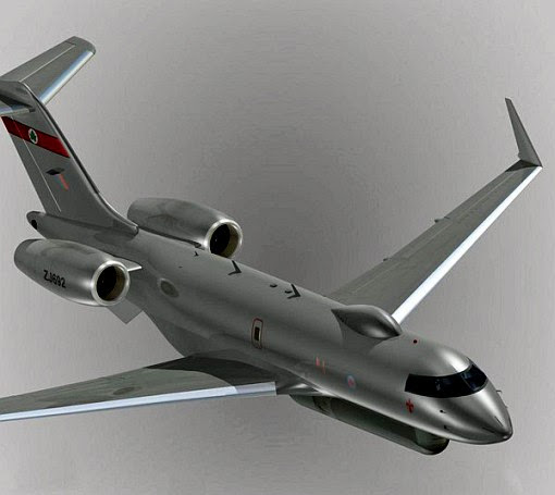
The UK Royal Air Force (RAF) has hailed the Airborne Stand-Off Radar (ASTOR) system on the Sentinel R1 aircraft as a success after returning from trials in Afghanistan.

The aircraft is capable of operating for over nine hours at a time, during which it recognises and detects moving, static and fixed targets on the ground.

UK Minister for Defence, Equipment and Support, Quentin Davies said that the hugely sophisticated system successfully demonstrated what it could do in Afghanistan.

Raytheon Sentinel aicraft with ASTOR radar

"The ASTOR system is a key element of the modern network-enabled battlefield, through which our forces can learn about the movement of enemy forces and react to prevent those threats to our troops," he said.