Thursday, June 12, 2014
Thursday, June 5, 2014
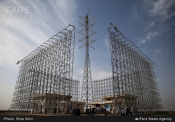
Iran launches cutting-edge Ghadir radar system
Iran's Islamic Revolution Guards Corps (IRGC) has officially put into service a domestically developed long-range radar system capable of detecting stealth aircraft.
The advanced radar system, named Ghadir, was unveiled in a ceremony attended by military top brass, including Commander of Khatam al-Anbiya Air Defense Base Brigadier General Farzad Esmaeili on Monday.
The state-of-the art radar system uses three-dimensional (3-D) technology to detect airborne targets, including radar-evading aircraft, cruise and ballistic missiles, and satellites in low Earth orbits. The system was first unveiled during the Great Prophet 6 military drills in 2011. It was later mass produced by the IRGC's Aerospace Division and underwent several tests in recent months
The Phased Array radar can monitor targets within a radius of 1,100 kilometers at a maximum 300-km altitude.
In November 2013, Iranian navy unveiled an indigenous state-of-the-art array radar system, dubbed Asr (Age), which can detect long-distance targets.
In recent years, Iran has made major breakthroughs in its defense sector and attained self-sufficiency in producing important military equipment and systems.
Despite its great defense achievements, the Islamic Republic has repeatedly said its military might poses no threat to other countries, insisting that its defense doctrine is merely based on deterrence.

Иранская РЛС дальнего обнаружения Ghadir
В Иране наконец-то представили трехкоординатную РЛС дальнего обнаружения Ghadir, о строительстве и испытаниях которой много говорили в последние годы. РЛС построена в шахрестане Гермсар остана Семнан, дальность обнаружения целей составляет до 1100 км и высота до 300 км.
Wednesday, May 28, 2014
Казахстан собирается приобрести РЛС GM400
22 мая 2014 года на проходившей в столице Казахстана Астане оборонной выставке KADEX-2014 компания ThalesRaytheonSystems (TRS, совместное предприятие французской группы Thales и американской корпорации Raytheon) подписала меморандум о взаимопонимании о предстоящей поставке для Сил воздушной обороны Казахстана 20 наземных радиолокационных станций Ground Master 400 (GM400). В соответствии с меморандумом, сборка РЛС GM400 для Казахстана будет организована совместным предприятием Granit - Thales Electronics с участием Thales и казахстанского ТОО "СКТБ "Гранит" (Алма-Ата). РЛС получила в Казахстане обозначение "НУР". На выставке KADEX-2014 демонстрировался локализованный образец РЛС "НУР" (GM400), выполненный на базе автомобиля "КамАЗ".
РЛС "НУР" (ThalesRaytheonSystems Ground Master 400) в экспозиции выставки KADEX-2014. Астана, май 2014 года (с) ВКонтакте

Monday, April 28, 2014
Radar Research and Development Lab in Moscow

RRDL site – in Russian, content includes bibliography of their publications, review of modern radars and SAR, materials about multistatic radars/SAR, target detection, noise and passive radars…
Friday, April 25, 2014
The Python ART Radar Toolkit
The Python ARM Radar Toolkit, Py-ART, is a Python module containing a collection of weather radar algorithms and utilities. Py-ART is used by the Atmospheric Radiation Measurement (ARM) Climate Research Facility for working with data from a number of its precipitation and cloud radars, but has been designed so that it can be used by others in the radar and atmospheric communities to examine, processes, and analyze data from many types of weather radars.
What can Py-ART do?
Py-ART has the ability to ingest (read) from a number of common weather radar formats including Sigmet/IRIS, MDV, CF/Radial, UF, and NEXRAD Level II archive files. Radar data can be written to NetCDF files which conform to the CF/Radial convension.
Py-ART also contains routines which can produce common radar plots including PPIs and RHIs.


Algorithms in the module are able to performs a number of corrections on the radar moment data in antenna coordinate including attenuation correction of the reflectivity, velocity dealiasing, and correction of the specific (Kdp) and differential (PhiDP) phases.
A sophisticated mapping routines is able to efficiently create uniform Cartesian grids of radar fields from one or more radars. Routines exist in Py-ART for plotting these grids as well as saving them to NetCDF files.