RRDL site – in Russian, content includes bibliography of their publications, review of modern radars and SAR, materials about multistatic radars/SAR, target detection, noise and passive radars…
Review of Radar Science, Technology, Applications, News, Publications, Industry, History, etc.
Monday, April 28, 2014
Friday, April 25, 2014
The Python ART Radar Toolkit
The Python ARM Radar Toolkit, Py-ART, is a Python module containing a collection of weather radar algorithms and utilities. Py-ART is used by the Atmospheric Radiation Measurement (ARM) Climate Research Facility for working with data from a number of its precipitation and cloud radars, but has been designed so that it can be used by others in the radar and atmospheric communities to examine, processes, and analyze data from many types of weather radars.
What can Py-ART do?
Py-ART has the ability to ingest (read) from a number of common weather radar formats including Sigmet/IRIS, MDV, CF/Radial, UF, and NEXRAD Level II archive files. Radar data can be written to NetCDF files which conform to the CF/Radial convension.
Py-ART also contains routines which can produce common radar plots including PPIs and RHIs.
Algorithms in the module are able to performs a number of corrections on the radar moment data in antenna coordinate including attenuation correction of the reflectivity, velocity dealiasing, and correction of the specific (Kdp) and differential (PhiDP) phases.
A sophisticated mapping routines is able to efficiently create uniform Cartesian grids of radar fields from one or more radars. Routines exist in Py-ART for plotting these grids as well as saving them to NetCDF files.
Wednesday, April 23, 2014
ПВО Сирии
Башару Асаду нужно очень постараться, чтобы сорвать планы запада по «переформатированию» его страны
Уже больше года внимание всего мира приковано к ближневосточному региону, где в очередной раз решается судьба многих народов мусульманских стран. Новым объектом непосредственных государственных интересов США и их союзников по НАТО явилась Сирия с неугодным Западу режимом Башара Асада. Страна балансирует на грани настоящей гражданской войны с многочисленными людскими и материальными потерями. Гибнет мирное население, противоборствующие стороны, как водится, взаимно возлагают вину за это друг на друга. Отряды оппозиции, поддерживаемые Западом, приобретают организованную структуру, единое управление, получают поддержку вооружением, боеприпасами, продовольствием и т.п. с территории Турции, Ирака, Иордании, Ливана, так как сухопутные и воздушные границы Сирии практически открыты. Правительственные войска удерживают города и крупные населенные пункты, в то время как оппозиция контролирует около половины территории страны, включая почти всю сельскую местность.
Tuesday, April 22, 2014
Monday, April 21, 2014
Sunday, April 20, 2014
A new course in September 2014
Dr Jeanine Engelbrecht, Senior Researcher in the field of Synthetic Aperture Radar at the CSIR Meraka Institute in Rosebank, Cape Town, will be presenting in the University of Cape Town a course on Applications of Imaging Radar from 1 to 4 September 2014.
Dr Engelbrecht has over 10 years of remote sensing and spatial analysis experience. Her research and development focus has been on exploiting SAR technologies for a variety of applications including geological applications, hydrological applications and engineering geological aspects.
Her course will introduce participants to the principles of imaging radar with a particular focus on end-user applications, looking, for instance, at how signal processing of data collected from satellite-borne sensors can aid in the extraction of biophysical and geophysical parameters.
The backscattering characteristics of SAR signals will be identified, and students will learn how the information can be applied for 1) food security, 2) environmental applications, 3) disaster monitoring and relief, 4) defence peace safety and security and 6) human environments.
The course will consist of theory lectures as well as practical hands-on sessions in SAR image processing for a variety of applications.
More information can be found in this PDF: EEE 5012Z (2014) – Applications of Imaging Radar.
Wednesday, April 16, 2014
Python-3 Ground Penetrating Radar
Wireless Monostatic Ground Penetrating Radar with one receiving-transmitting antenna Python-3.
Features
- FREQUENCES: 100 / 50 / 38 / 25 MHz
- ANTENNA LENGTH: from 1 m to 4 m, depends on selected frequency
- WEIGHT: from 10 kg to 20 kg, depends on selected frequency
- TIME RANGE: from 1 to 1500 ns, step 1 ns
- SCAN RATE: 28 scans per second
- SAMPLES PER SCAN: 1024 samples per scan
- RESOLUTION: 16 bit
- FILTERS: Preset and Customized digital filters.
- GAIN: 9 points digital gain function
- DATA TRANSFER: through built-in Wi-Fi to PC.
- POWER: Built-in battery 12 V, 9 A*h with battery life more than 7 h
Python-3 georadar is a portable digital subsurface sounding radar carried by a single operator, especially used for deep surveys (up to 50 meters* in favorable ground). The unit is designed for solving a long-range of geotechnical, geological, engineering and other tasks wherever nondestructive operational environmental monitoring is needed. In the sounding process, the operator is getting real-time information as a radiolocation profile (sometimes also referred to as radargram) on a display. At the same time, data are recorded on a hard disc for further use (processing, printout, interpretation, etc.). Examples of radiolocation profiles you can see below.
Thursday, April 10, 2014
Software Defined Radar Simulator
Github software project “The Software Defined Radar Simulator” is designed to provide in SystemC an accurate simulation of commonly-used SDR blocks. These models provide both run-time and compile-time adjustable parameters. Currently these blocks include:
- Phase Accumulator
- CORDIC down-converter
- CIC Filter (includes optional bit-pruning)
- FIR Filter
- Stimulus class to assist in test bench development
- Signal Generator classes to assist in testing.
- Recorder class to collect test output data.
Dependencies:
- SystemC version 2.3 software.
- Latest version of GCC.
- Latest version of Boost libraries ( www.boost.org ).
- Waf build tool.
- Yaml-cpp version 0.5.1 software.
Wednesday, April 9, 2014
Sense-And-Avoid Still Causing Triton Turbulence
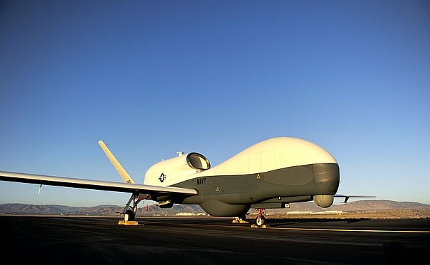
The U.S. Navy continues to assess its options to replace a sense-and-avoid radar that was to be used on the Northrop Grumman MQ-4C Triton unmanned aircraft, but failed to meet expectations.

Exelis was selected by Northrop to provide the radar, but the Navy put a stop-work on the contract one year ago and began an assessment of alternatives. No alternative is available off the shelf, says Sean Burke, Navy deputy program manager. The problem was miniaturizing the advanced, electronically scanned array (AESA) radar technology and providing sufficient cooling and power within the available weight and space. It was a “technical solution that turned out to be very challenging for us,” Burke said.
“We are really at the edge of the technology” in developing the system, said Mike Mackey, Northrop Grumman’s Triton program manager. He and Burke briefed the media on the program during the annual Sea-Air-Space 2014 show hosted by the Navy League.
Tuesday, April 8, 2014
Airbus Defence and Space receives radar contract extension in the Middle East
Airbus Defence and Space has been awarded a contract for the delivery of four of its Spexer 2000 security radars to further improve the surveillance of the borders of a major Middle Eastern country. The contract is an extension to an existing contract for the delivery of more than 40 Spexer 2000 radars, which have been operating successfully for almost two years now.

Thomas Müller, head of the Business Line Electronics at Airbus Defence and Space, said: “Spexer 2000 is using state-of-the-art Active Electronically Scanning Array (AESA) technology, which provides a multi-tasking and multi-mode capability, and increases the detection and target assessment capability substantially. Due to this, Spexer 2000 can replace several conventional radars.”
Friday, April 4, 2014
Get ready for software-defined RADAR
With a big RF transmitter and enough fast computing power, you have the ability to do a lot of different things, as evidenced by a General Electric presentation on "software-defined radar" at the GPU conference this year.
At GTC 13 last year, GE gave a standing-room-only presentation about how it's using RDMA (Remote Direct Memory Access) to drive multi-GPU process performance to new heights. The firm was back this year to talk about new and innovative applications of GPU tech it has cooked up over the past year.
How it works: Simultaneous transmit/receive for a whole load of functions
In its session, Dustin Franklin, GE GPU Applications Engineer guru, gives us an update on how it has been proceeding with RDMA and how it allows the electric company to build large scale, multi-node, products.
Thursday, April 3, 2014
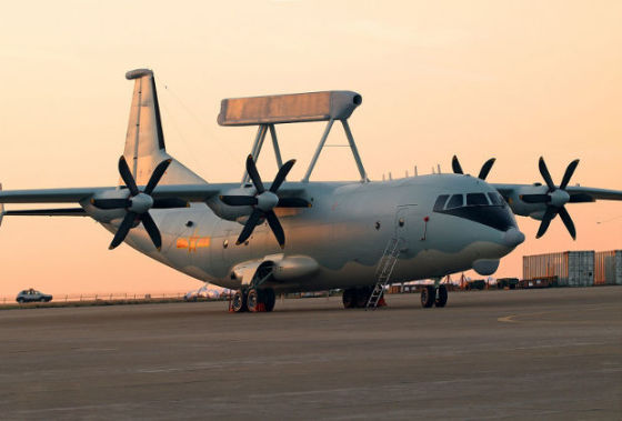
Мировой рынок самолетов ДРЛОиУ в 2010-2017 гг.
ЦАМТО, 31 марта. В предстоящий четырехлетний период (2014-2017 гг.) объем экспортных продаж новых самолетов ДРЛОиУ составит 11 машин на сумму 4,376 млрд дол в случае выполнения графиков поставок по текущим контрактам, заявленным намерениям и проводимым тендерам.

По оценке ЦАМТО, в прошедший 4-летний период (2010-2013 гг.) было поставлено на экспорт или произведено по лицензии не менее 30 новых самолетов на сумму 8,225 млрд дол.
Всего в 2010-2013 гг. было экспортировано 32 самолета ДРЛОиУ на сумму 8,3 млрд дол. При этом объем продаж новых самолетов в период 2010-2013 гг. составил 93,75% от общего количества или 99,1% от стоимости общемировых поставок.
В 2014-2017 гг. сокращение рынка в процентном выражении по сравнению с предыдущим 4-летним периодом составит 63,3% в количественном выражении и 46,8% – в стоимостном.
В 2010-2013 гг. средняя потребность в новых самолетах ДРЛОиУ на международном рынке составила почти 8 машин в год. В 2014-2017 гг. ежегодный спрос сократится до 3 ед.
По методике ЦАМТО, в категорию «новые» включены поставки новых самолетов ДРЛОиУ, а также поставки самолетов из состава ВС стран-экспортеров, модернизированных до уровня практически новых машин с продленным сроком эксплуатации, цена которых на момент поставки составляет более 50% от стоимости нового самолета того же типа на тот же период времени, но не менее 100 млн дол.
Первое место по периоду 2010-2017 гг. в рейтинге поставщиков новых самолетов ДРЛОиУ традиционно занимают США (17 машин на сумму 6,745 млрд дол). В 2010-2013 гг. на экспорт было поставлено 13 самолетов стоимостью 5,145 млрд дол, в 2014-2017 гг. поставки сократятся втрое и составят всего 4 новые машины на сумму 1,6 млрд дол (см. примечание).
Второе место по периоду 2010-2017 гг. занимает Швеция с комплексом ДРЛОиУ «Эриай», устанавливаемым на платформы по желанию заказчика (9 самолетов на сумму 2,111 млрд дол). В 2010-2013 гг. на экспорт было поставлено 8 самолетов стоимостью 1,444 млрд дол, на 2014-2017 гг. прогнозируется поставка 1 новой машины на сумму 667 млн дол.
Третье место по периоду 2010-2017 гг. занимает Израиль (7 машин на сумму 2,117 млрд дол). Поставки обеспечены комплексом ДРЛОиУ «Фалкон», устанавливаемым на платформы по желанию заказчика, и новейшей разработкой – компактной системой ДРЛОиУ CAEW на базе бизнес-лайнера G-550 «Гольфстрим». В 2010-2013 гг. на экспорт было поставлено 5 самолетов стоимостью 1,358 млрд дол, на период 2014-2017 гг. портфель заказов составляет 2 новые машины на сумму 758,6 млн дол.
Четвертое место с поставкой Пакистану в первом четырехлетнем периоде 4 самолетов ДРЛОиУ на базе комплекса KJ-200 стоимостью 278 млн дол занимает Китай.
По категории «тендер», результаты которых пока не подведены, в 2017 году возможна поставка 4 самолетов ДРЛОиУ на сумму около 1,35 млрд дол.
Примечание: в расчете не учтен контракт Катара с «Боингом» на поставку трех самолетов ДРЛОиУ общей стоимостью 6,6 млрд риалов (1,81 млрд дол), о подписании которого было объявлено 27 марта этого года.
Более подробный материал с табличными данными опубликован в журнале «Мировая торговля оружием» №2.
Права на данный материал принадлежат ЦАМТО
Материал был размещен правообладателем в открытом доступе.
Tuesday, April 1, 2014
Подсолнух-Э
«Подсолнух-Э» - всепогодный береговой загоризонтный радар поверхностной волны (БЗГР) коротковолнового диапазона радиоволн, предназначенный для контроля надводной и воздушной обстановки в пределах 200-мильной экономической зоны прибрежного государства в составе береговых систем (ОАО НПК «Ниидар»). - Источник: rusarmy.com
Любопытной может стать сделка по продаже Бразилии загоризонтных РЛС «Подсолнух» – как заявил наш источник, бразильские военные оказались в восторге от демонстрации возможностей этого комплекса обнаруживать и отслеживать морские надводные и воздушные цели в сотнях км от берега в условиях реального времени. Российская армия имеет данные комплексы на вооружении на побережье Каспийского моря, и если сделка с Бразилией состоится, это станет первой поставкой данных РЛС за рубеж. - Деловая газета "Взгляд".

